


Arnold, CA…Heavy Snow Possible Over The Mountains Thursday through
Friday. A cold Pacific storm system is forecast to move through the
interior of Northern California on Thursday and Thursday night,
with snow showers continuing through the day on Friday. Snow
levels will lower rapidly with this storm, dropping to around
4000 feet Thursday night, and hovering between 3000 and 4000 feet
Friday. In addition, gusty winds during the storm may bring poor
visibilities.
Winter Storm Watch
URGENT – WINTER WEATHER MESSAGE
National Weather Service Sacramento CA
421 AM PST Wed Jan 17 2018
…Heavy Snow Possible Over The Mountains Thursday through
Friday…
.A cold Pacific storm system is forecast to move through the
interior of Northern California on Thursday and Thursday night,
with snow showers continuing through the day on Friday. Snow
levels will lower rapidly with this storm, dropping to around
4000 feet Thursday night, and hovering between 3000 and 4000 feet
Friday. In addition, gusty winds during the storm may bring poor
visibilities.
CAZ068-069-180030-
/O.CON.KSTO.WS.A.0002.180118T2000Z-180120T0000Z/
Western Plumas County/Lassen Park-
West Slope Northern Sierra Nevada-
421 AM PST Wed Jan 17 2018
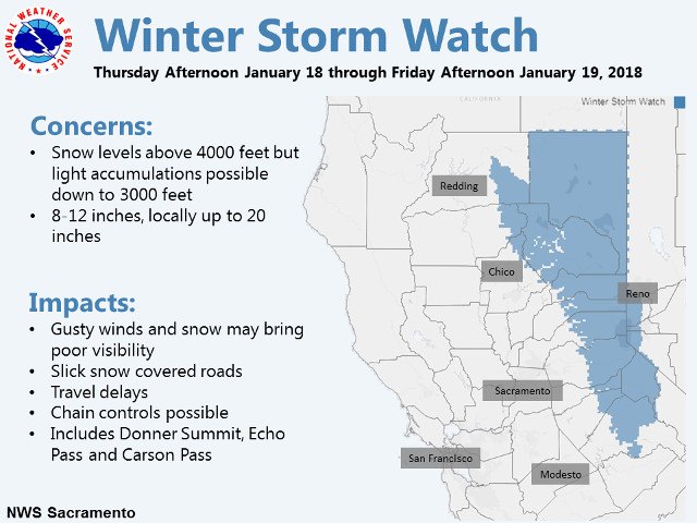
…WINTER STORM WATCH REMAINS IN EFFECT FROM THURSDAY AFTERNOON
THROUGH FRIDAY AFTERNOON ABOVE 4000 FEET…
* WHAT…Heavy snow possible. Plan on difficult travel conditions
and chain controls. Total snow accumulations of 4 to 7 inches,
with localized amounts up to 20 inches possible. Light snow
accumulations are possible down to 3000 feet.
* WHERE…Western Plumas County/Lassen Park and West Slope
Northern Sierra Nevada. including Interstate 80 over Donner
Summit, Highway 50 over Echo Pass, and Highway 88 over Carson
Pass.
* WHEN…From Thursday afternoon through Friday afternoon.
* ADDITIONAL DETAILS…Significant reductions in visibility are
possible.
PRECAUTIONARY/PREPAREDNESS ACTIONS…
A Winter Storm Watch means there is potential for significant
snow, sleet or ice accumulations that may impact travel. Continue
to monitor the latest forecasts.
$$
Winter Storm Watch For Thursday & Friday added by admin on
View all posts by admin →