


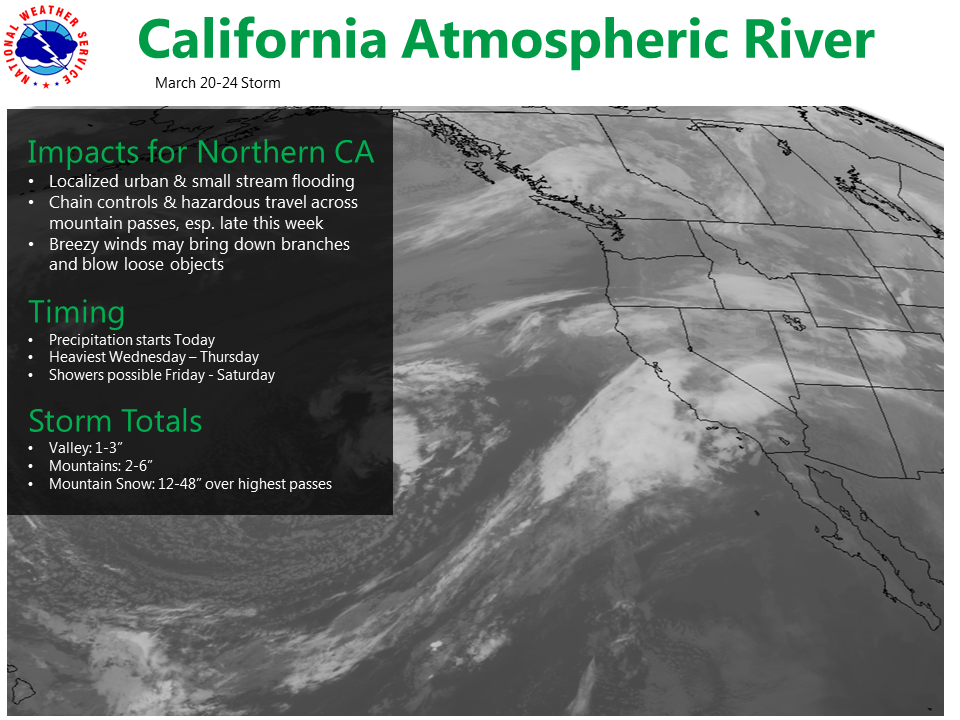
Arnold, CA…Heavy Snow Possible Late Tonight thru Thursday night. An atmospheric river will take aim at California this week. Snow levels will remain above major pass levels through through this evening, but will lower late tonight as a storm system from the Gulf of Alaska arrives. Heavy snow will be possible above 6500 feet with the potential for travel delays and chain controls. Total snow accumulations of 6 to 12 inches, with localized amounts up to 20 inches, are possible.
Winter Storm Watch
URGENT – WINTER WEATHER MESSAGE
National Weather Service Sacramento CA
300 AM PDT Wed Mar 21 2018
…Heavy Snow Possible Late Tonight thru Thursday night…
.An atmospheric river will take aim at California this week. Snow
levels will remain above major pass levels through through this
evening, but will lower late tonight as a storm system from the
Gulf of Alaska arrives. Heavy snow will be possible above 6500
feet with the potential for travel delays and chain controls.
CAZ068-069-220000-
/O.CON.KSTO.WS.A.0009.180322T0600Z-180323T0600Z/
Western Plumas County/Lassen Park-
West Slope Northern Sierra Nevada-
300 AM PDT Wed Mar 21 2018
…WINTER STORM WATCH REMAINS IN EFFECT LATE TONIGHT THROUGH
THURSDAY EVENING ABOVE 6500 FEET…
* WHAT…Heavy snow possible. Plan on difficult travel
conditions. Total snow accumulations of 6 to 12 inches, with
localized amounts up to 20 inches, are possible.
* WHERE…Western Plumas County/Lassen Park and West Slope
Northern Sierra Nevada…including Donner Summit over Interstate
80, Echo Summit over Highway 50, and Carson Pass over Highway
88.
* WHEN…Late tonight through Thursday evening.
* ADDITIONAL DETAILS…Significant reductions in visibility are
possible.
PRECAUTIONARY/PREPAREDNESS ACTIONS…
A Winter Storm Watch means there is potential for significant
snow, sleet or ice accumulations that may impact travel. Continue
to monitor the latest forecasts.
$$
Miracle March Continues with an Atmospheric River Event Starting Tonight added by admin on
View all posts by admin →