


Arnold, CA….The National Weather has issued an update on the Weather Changes for Interior Northern California this Week…A couple of Pacific weather systems will bring rain, mountain snow, breezy winds and colder temperatures to interior northern California this week. The first Pacific weather system will weaken at it moves inland today. This system will bring light rain mainly to the mountains in northern California, and locally breezy winds and cooler temperatures. Snow levels will generally remain above the Sierra Nevada passes.
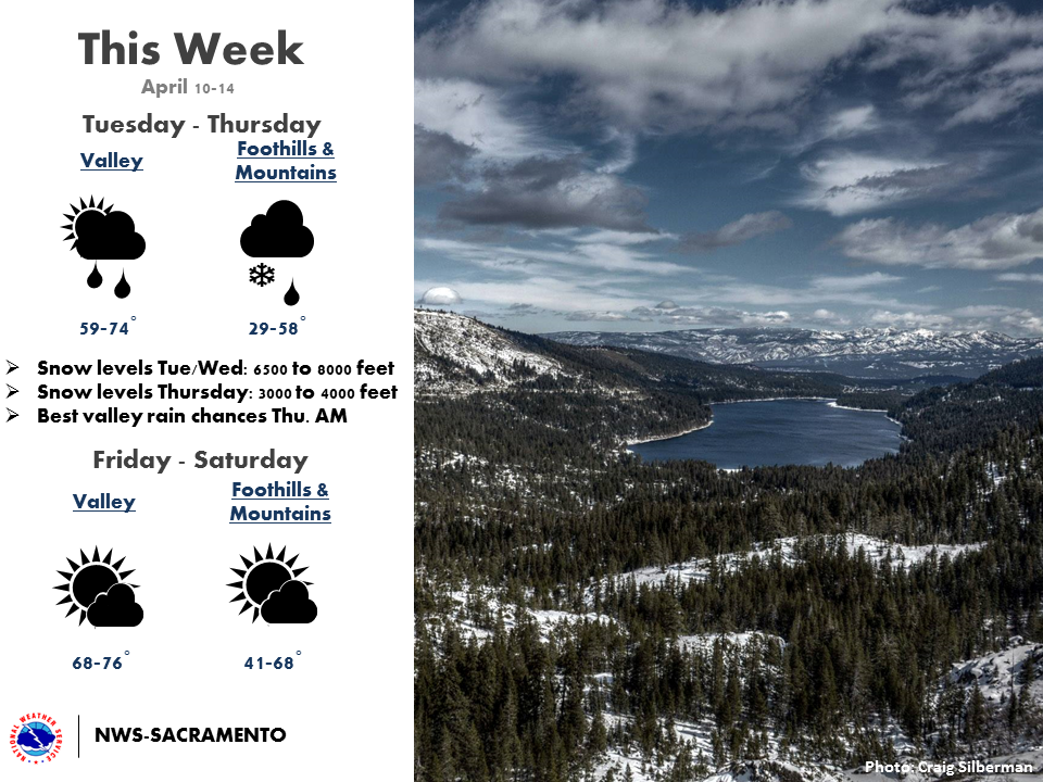
A second, colder and wetter system will follow for Wednesday and Thursday. Snow levels are forecast to rapidly lower below the passes Wednesday night, eventually lowering to around 2500 feet in the Shasta County mountains to around 3000 feet over the Sierra.
Six inches to a foot of snow is possible over the Sierra passes with a dusting to around 3000 feet by Thursday, and several inches over the Shasta County mountains and the Coastal Range.
Travelers over the mountain passes should be prepared for winter driving conditions Wednesday night through Thursday.
High temperatures on Thursday will be much colder than normal with highs in the upper 50s to lower 60s in the Valley and mainly in the 30s and 40s in the mountains.
Special Weather Statement
Special Weather Statement
National Weather Service Sacramento CA
523 AM PDT Tue Apr 10 2018
CAZ013>019-063-064-066>069-102300-
Shasta Lake Area / Northern Shasta County-
Burney Basin / Eastern Shasta County-Northern Sacramento Valley-
Central Sacramento Valley-Southern Sacramento Valley-
Carquinez Strait and Delta-Northern San Joaquin Valley-
Mountains Southwestern Shasta County to Northern Lake County-
Clear Lake/Southern Lake County-
Northeast Foothills/Sacramento Valley-Motherlode-
Western Plumas County/Lassen Park-
West Slope Northern Sierra Nevada-
Including the cities of Shasta Dam, Burney, Redding, Red Bluff,
Chico, Oroville, Marysville/Yuba City, Sacramento,
Fairfield/Suisun, Stockton, Modesto, Alder Springs, Lakeport,
Paradise, Grass Valley, Jackson, Chester, Quincy, and Blue Canyon
523 AM PDT Tue Apr 10 2018
…Weather Changes for Interior Northern California this Week…
A couple of Pacific weather systems will bring rain, mountain
snow, breezy winds and colder temperatures to interior northern
California this week.
The first Pacific weather system will weaken at it moves inland
today. This system will bring light rain mainly to the mountains
in northern California, and locally breezy winds and cooler
temperatures. Snow levels will generally remain above the Sierra
Nevada passes.
A second, colder and wetter system will follow for Wednesday and
Thursday. Snow levels are forecast to rapidly lower below the
passes Wednesday night, eventually lowering to around 2500 feet in
the Shasta County mountains to around 3000 feet over the Sierra.
Six inches to a foot of snow is possible over the Sierra passes
with a dusting to around 3000 feet by Thursday, and several inches
over the Shasta County mountains and the Coastal Range.
Travelers over the mountain passes should be prepared for winter
driving conditions Wednesday night through Thursday.
High temperatures on Thursday will be much colder than normal with
highs in the upper 50s to lower 60s in the Valley and mainly in
the 30s and 40s in the mountains.
$$
Rain & Snow Return To Our Area This Week added by admin on
View all posts by admin →