

Awahanee, CA, July 21, 2018 – The Ferguson Fire started July 13 on the Sierra National Forest and is managed under unified command between the United States Forest Service, California Interagency Incident Management Team 4, CALFIRE and the Mariposa County Sheriff’s Office. Much of the fire is burning in steep, rugged terrain with little to no access roads. Mandatory and advisory evacuations are in place in several areas but no homes have been damaged or destroyed.
Click Above for Full Detailed Map
The Ferguson Fire is burning in very rough terrain with high firefighter exposure due to very hot conditions and limited access requiring heavy rotor wing support. The fire grew more than 2,500 acres throughout the day and into the night hours Friday. Prior to the Rough Fire, this river canyon held the record for the largest fire on the Sierra NF which burned in 1924.
Yosemite National Park Remains open.
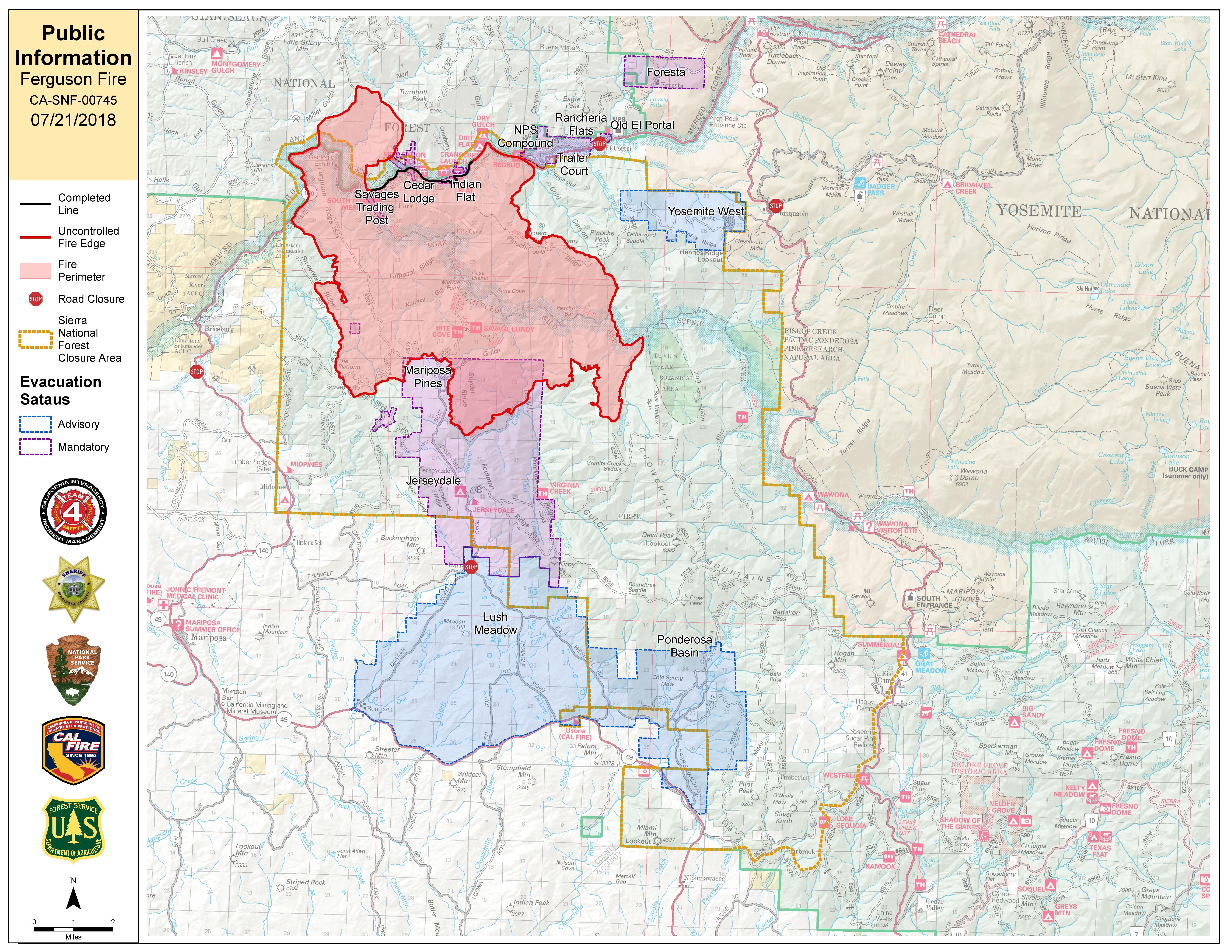
The fire is 27,129 acres with 7% containment. 2,832 personnel are currently engaged on the fire which includes 204 engines, 38 water tenders, 17 helicopters, 70 crews, and 40 dozers.
Road Closures:
Hwy 140 is closed from 1.9 miles east of Midpines to the Cedar Lodge area MOTORISTS ARE ADVISED TO USE AN ALTERNATE ROUTE
Mandatory Evacuations:
These area are currently under a mandatory evacuation include:
El Portal Trailer Court
Incline Rd from Clearing House to the last BLM campground
Jerseydale/ Mariposa Pines
Cedar Lodge/ Indian Flat Campground
Savage’s Trading Post
Sweetwater Ridge
El Portal Trailer Court
Rancheria Flat – Government Housing
Old El Portal
Yosemite View Lodge
Foresta
Yosemite West
Evacuation Advisory:
This is NOT an Evacuation Order. This is an advisement only of a potential Evacuation Order should conditions change.
• Lushmeadows Community
• Ponderosa Basin Community
• Triangle Rd from Jerseydale Rd to Hwy 49 South including all side roads.
• Darrah Rd from Triangle to Sherrod Rd
• East side of Hwy 49S from Darrah Rd to Harris Rd- This includes Boyer Rd, Woodland Area, Wass Rd, Tip Top Rd
Evacuation Center:
New Life Christian Fellowship, 5089 Cole Rd, Mariposa, CA 95338
Yosemite Valley Elementary School, 9009 Lost Arrow Rd, Yosemite National Park, CA 95389
Animal Shelters: Small animals, SPCA, 5599 California 49, Mariposa, CA 95338 and large animals, Mariposa County Fairgrounds, 5007Fairgrounds Road, Mariposa, CA 95338
Cooperators: California Highway Patrol, CalTrans, Pacific Gas and Electric, California Conservation Corps, Mariposa County Public Works and the American Red Cross
.
.
.
.
Incident Information
Basic Information
Current as of 7/21/2018, 6:48:55 AM
Incident Type Wildfire
Cause Unknown
Date of Origin Friday July 13th, 2018 approx. 08:30 PM
Location Savage Trading Post area
Incident Commander Jay Kurth, California Interagency Incident Management Team 4
Coordinates 37.652 latitude, -119.881 longitude
Current Situation
Total Personnel 2,832
Size 27,129 Acres
Percent of Perimeter Contained 7%
Fuels Involved
Brush and timber, burning is steep inaccessible terrain.
Significant Events
Hwy 140 is closed from 1.9 miles east of Midpines to the Cedar Lodge area MOTORISTS ARE ADVISED TO USE AN ALTERNATE ROUTE
Outlook
Remarks
The Incident base for the Ferguson Fire is at the Ahwanee Regional Park. CA IMT 4 (Kurth) took command of the Ferguson Fire and is in unified command with CALFIRE and the Mariposa County Sheriff’s Office.
Ferguson Fire Jumps Hwy 140 & Grows to 27,129 Acres! 204 Engines, 38 Water Tenders, 17 Helicopters, 70 Hand Crews, 40 Dozers, & 2,832 Total Personnel added by admin on
View all posts by admin →