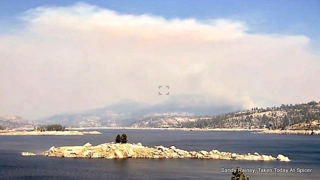
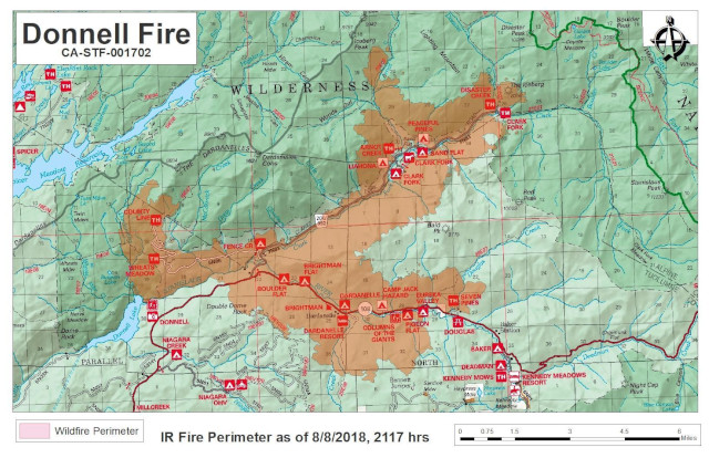
Pinecrest, CA…The fire pushed further up the Arnot and Disaster Creek drainages to the northeast. The fire crossed Douglas Creek on the north side of Highway 108. Overnight crews continued to make progress constructing dozer and hand lines off the Eagle Meadow (5N01) Road. Increased fire activity is expected today due to the lifting of the inversion layer and stronger southwest winds. Structure protection continues to be the priority along Highway 108 and the Eagle Meadow Road, including protecting the Bennett Juniper.
Click Above For Full Sized Image

RECREATION RESIDENCE AND FACILITY UPDATE: As of August 8, at 8:45 PM the Wagner and Riverside recreation tracts and Dardanelle Resort reviews have been completed and all permittees contacted regarding the condition of their cabin/resort. Fourteen of 16 cabins in the Wagner Tract as well as the Dardanelle Store were destroyed in the fire. None of the cabins within the Riverside Tract were destroyed. The assessment team continues to evaluate structure conditions along Highway 108, and the Forest Service is contacting permittees as soon as information is available.
Highway 108 is still closed at Eagle Meadow Road from the west and at the top of Sonora Pass on the east side. The Alpine County Sheriff’s Office has closed the gate at the junction of Highway 4 and Highlands Lake Road (Forest Service Road 8N01). The Pacific Crest Trail has also been closed between Highway 108 and Highway 4 for public safety.
The incident is in Unified Command with Central Coast Interagency Incident Management Team, Tuolumne County Sheriff’s Office and Tuolumne County Fire Department.
The fire started at the inlet of Donnell Reservoir and continues to burn along the Middle Fork of the Stanislaus River in steep and inaccessible terrain. It has spread to both sides of Highway 108 near Brightman. The fire is burning north into the Carson Iceberg Wilderness between the Arnot Creek and Disaster Creek drainages and east to Eureka Valley along Highway 108.
Mandatory Evacuations: In effect along Highway 108 from Eagle Meadow Road to Kennedy Meadows (all residences and campgrounds) as well as all along Eagle Meadow Road (5N01) and the Clark Fork Road area. No new mandatory evacuations have been ordered.
Advisory Evacuation for Mill Creek area was put into effect on August 8.
For more information about the Stanislaus National Forest, visit us at www.fs.usda.gov/stanislaus, “like” us on Facebook at www.facebook.com/StanislausNF, or “follow” us on Twitter at www.twitter.com/StanislausNF.
For more information on the fire please go to https://inciweb.nwcg.gov/incident/6092/
Fire Information Line: (209) 536-5388 donnellfirestf1918@gmail.com
LOCATION: Stanislaus National Forest DATE STARTED: August 1, 2018
ACRES: 21,097 PERCENT CONTAINED: 6%
STRUCTURES THREATENED: 220 STRUCTURES DESTROYED: 55
INJURIES/ACCIDENTS: 0 MINOR STRUCTURES DESTROYED: 81


