


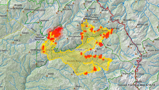
Bear Valley, CA…A smoke column is visible from Highway 4 north of Spicer Reservoir. Fire activity in this area increased due to steep, dense vegetation, dry fuels and gusty south and southwestern winds. Uncommon fire activity at night has been observed in the northwestern portion of the Carson-Iceberg Wilderness. Expect increased aviation in the area as air tankers and helicopters make multiple drops to try to moderate fire activity. Hiram historic cabin has been wrapped with fire resistant material and vegetation cleared to protect the structure in the event fire continues to spread north. Additional containment line was completed on the northwest and southeast portions of the fire. With the current conditions including warming temperatures, lower humidity, increased winds up to 25 mph and low fuel moistures, vegetation is incredibly receptive to long distance spotting. Moderate fire activity remains on the northeastern and eastern edges of the fire. Hazard tree mitigation continues along Highway 108.
We will be heading into a drier and warmer period through the weekend along with gusty afternoon west to southwest winds. This may make for more active fire conditions in the coming days.
Fire personnel are maintaining an excellent accident and injury record. Support from the local community continues to bolster firefighter morale.
Current Closures:
August 4: California Highway Patrol closed Highway 108 at Eagle Meadow Road from the west and at the top of Sonora Pass on the east side.
August 6: U.S. Forest Service closed the Pacific Crest Trail between Highway 108 and Highway 4 for public safety.
August 9: Alpine County Sheriff’s Office closed the gate at the junction of Highway 4 and Highland Lakes Road (Forest Service Road 8N01).
August 9: U.S. Forest Service signed the Fire Closure Order restricting public access within and adjacent to the fire.
Mandatory Evacuations: Still in effect along Highway 108 from Eagle Meadow Road to Kennedy Meadows (all residences and campgrounds) as well as all along Eagle Meadow Road (5N01) and the Clark Fork Road area. No new mandatory evacuations have been ordered.
Advisory Evacuation: Mill Creek area was put into effect on August 8th.
For more information about the Stanislaus National Forest, visit us at www.fs.usda.gov/stanislaus, “like” us on
Facebook at www.facebook.com/StanislausNF, or “follow” us on Twitter at www.twitter.com/Stanislaus_NF.
For more information on the fire please go to https://inciweb.nwcg.gov/incident/6092/
Thursday August 16, 2018 @ 8am
Fire Information Line: (209) 536-5388 donnellfirestf1918@gmail.com
LOCATION: Stanislaus National Forest DATE STARTED: August 1, 2018
ACRES: 30,079 PERCENT CONTAINED: 30%
STRUCTURES THREATENED: 220 STRUCTURES DESTROYED: 54
INJURIES/ACCIDENTS: 3 MINOR STRUCTURES DESTROYED: 81
TOTAL PERSONNEL: 873
Fire Resources include: 16 Hand Crews, 5 Helicopters, 46 Engines, 3 Dozers, 8 Water Tenders
Donnell Fire Morning Update, 30,079 Acres, 30% Contained, Fire Column North of Spicer added by admin on
View all posts by admin →