


Arnold, CA….The forecast for this week from the National Weather Service Sacramento Office for the West Slope Northern Sierra Nevada. Today Mostly sunny. A slight chance of showers and thunderstorms in the afternoon. Highs 48 to 63 higher elevations…63 to 71 lower elevations. Snow level above 8000 feet. Prevailing south winds up to 10 mph shifting to the west in the afternoon.
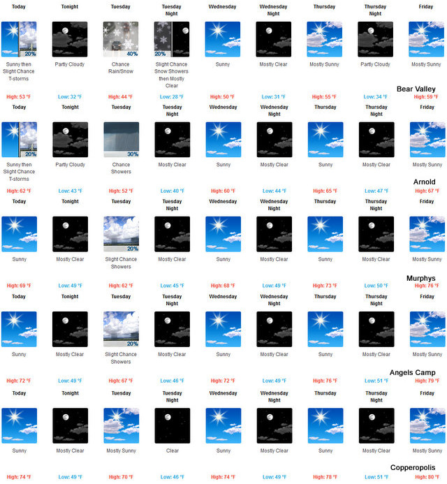
Tonight Partly cloudy. A slight chance of rain showers after midnight. Colder. Lows 28 to 43 higher elevations…40 to 50 lower elevations. Snow level above 8000 feet. Prevailing south winds up to 10 mph.
Tuesday Mostly cloudy. At lower elevations, a slight chance of rain showers in the morning, then a chance of rain showers in the afternoon. At higher elevations, a chance of rain and snow showers. Highs 37 to 52 higher elevations…52 to 62 lower elevations. No snow accumulation lower elevations…up to 1 inch higher elevations. Snow level 7500 feet. Prevailing southwest winds 5 to 15 mph with gusts to around 30 mph…except southwest 15 to 30 mph over ridges.
Tuesday Night Partly cloudy with a slight chance of rain and snow showers in the evening, then clear after midnight. Colder. Lows 23 to 38 higher elevations…37 to 47 lower elevations. Snow level 6500 feet. Prevailing east winds up to 10 mph.
Wednesday Sunny, warmer. Highs 45 to 60 higher elevations… 61 to 69 lower elevations. Prevailing east winds up to 10 mph shifting to the west in the afternoon.
Wednesday Night Mostly clear. Lows 31 to 46.
Thursday Mostly sunny. Warmer. Highs 54 to 69.
Thursday Night And Friday Mostly clear. Lows 33 to 48. Highs 56 to 71.
Friday Night Partly cloudy. Lows 35 to 50.
Saturday Partly cloudy with a chance of rain showers. Highs 56 to 71.
Saturday Night Mostly cloudy with a chance of rain showers. Lows 34 to 49.
Sunday Mostly cloudy with a chance of rain and snow showers. Highs 52 to 67.
Lower Temps to Start the Week & Then Warming Into the Weekend added by admin on
View all posts by admin →