


Arnold, CA…The National Weather Service in Sacramento has issued a Heat Advisory for today and tomorrow…”Hot Weather expected across Northern California Today and Tuesday…The first significant heat wave of the summer season is coming to northern California as strong high pressure builds over the region during the next few days. The Detailed forecast for Motherlode…
Today
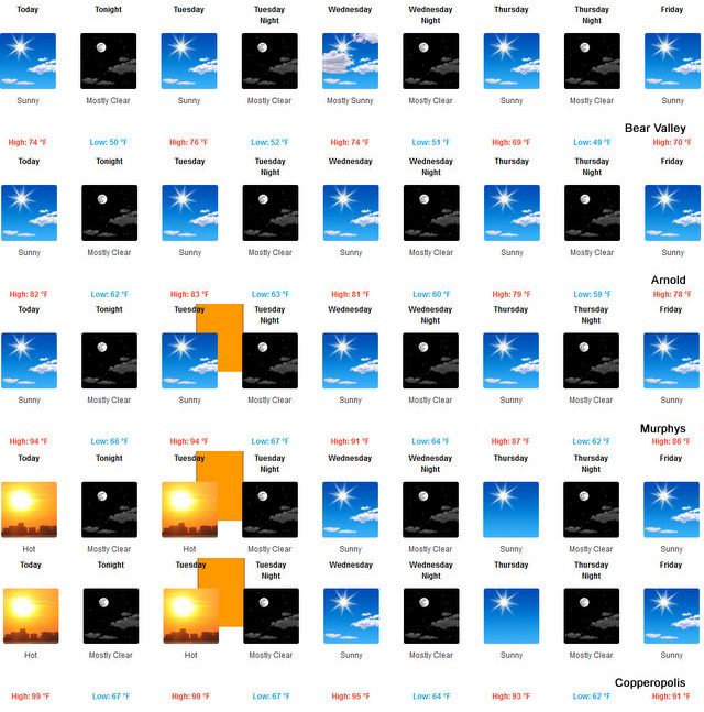
Mostly sunny. Warmer. Highs 88 to 100. Prevailing northeast winds up to 10 mph shifting to the west in the afternoon.
Tonight
Mostly clear. Lows 63 to 71. Prevailing northwest winds up to 10 mph shifting to the northeast after midnight.
Tuesday
Mostly sunny. Highs 89 to 101. Prevailing east winds up to 10 mph shifting to the southwest in the afternoon.
Tuesday Night
Mostly clear. Lows 64 to 70. Light winds.
Wednesday
Mostly sunny. Highs 86 to 98. Light winds.
Wednesday Night
Mostly clear. Lows 60 to 68.
Thursday
Sunny. Highs 84 to 94.
Thursday Night Through Saturday Night
Clear. Lows 57 to 65. Highs 81 to 94.
Sunday
Mostly sunny. Highs 81 to 93.
Detailed forecast for
West Slope Northern Sierra Nevada
Today
Mostly sunny. Warmer. Highs 68 to 83 higher elevations… 83 to 91 lower elevations. Prevailing east winds up to 10 mph shifting to the west in the afternoon.
Tonight
Mostly clear. Lows 44 to 59 higher elevations…58 to 68 lower elevations. Prevailing northwest winds up to 10 mph shifting to the east after midnight.
Tuesday
Mostly sunny. Highs 70 to 85 higher elevations…85 to 93 lower elevations. Prevailing east winds up to 10 mph shifting to the southwest in the afternoon.
Tuesday Night
Mostly clear. Lows 46 to 61 higher elevations… 60 to 68 lower elevations. Prevailing west winds up to 10 mph shifting to the northeast after midnight.
Wednesday
Mostly sunny. Highs 68 to 83 higher elevations… 82 to 90 lower elevations. Prevailing northeast winds up to 10 mph shifting to the west in the
afternoon.
Wednesday Night
Mostly clear. Lows 48 to 63.
Thursday
Sunny. Highs 69 to 84.
Thursday Night Through Friday Night
Mostly clear. Lows 47 to 62. Highs 69 to 84.
Saturday
Sunny. Highs 69 to 84.
Saturday Night And Sunday
Mostly clear. Lows 46 to 61. Highs 69 to 84.
Heat Advisory
URGENT – WEATHER MESSAGE
National Weather Service Sacramento CA
345 AM PDT Mon Jun 10 2019
…Hot Weather expected across Northern California Today and
Tuesday…
.The first significant heat wave of the summer season is coming
to northern California as strong high pressure builds over the
region during the next few days.
CAZ013-015-063-064-066-067-110130-
/O.CON.KSTO.HT.Y.0001.190611T2000Z-190612T0300Z/
Shasta Lake Area / Northern Shasta County-
Northern Sacramento Valley-
Mountains Southwestern Shasta County to Northern Lake County-
Clear Lake/Southern Lake County-
Northeast Foothills/Sacramento Valley-Motherlode-
Including the cities of Shasta Dam, Redding, Red Bluff,
Alder Springs, Lakeport, Paradise, Grass Valley, and Jackson
342 AM PDT Mon Jun 10 2019
…HEAT ADVISORY REMAINS IN EFFECT FROM 1 PM TO 8 PM PDT
TUESDAY…
* TEMPERATURE…95 to 104 in the foothills and lower mountain
elevations and 105 to 107 in the northern Sacramento Valley on
Tuesday.
* IMPACTS…Heat related illnesses such as heat exhaustion and
heat stroke can occur due to prolonged exposure to hot
temperatures. People most vulnerable include those who are
spending lots of time outdoors…those who do not have air
conditioning…young children…the elderly…and those with
chronic ailments.
Interact with us via social media
www.facebook.com/nws.sacramento
www.twitter.com/nwssacramento
PRECAUTIONARY/PREPAREDNESS ACTIONS…
Take extra precautions, if you work or spend time outside. When
possible, reschedule strenuous activities to early morning or
evening. Know the signs and symptoms of heat exhaustion and heat
stroke. Wear light weight and loose fitting clothing when
possible and drink plenty of water.
&&
Heat Advisory in Effect Through Tuesday as Summer Arrives added by admin on
View all posts by admin →