San Francisco, CA…As part of its Community Wildfire Safety Program (CWSP), Pacific Gas and Electric Company (PG&E) announced that it is expanding its network of weather stations and high-definition cameras to improve the company’s ability to predict and respond to extreme wildfire danger. By the end of 2019, PG&E plans to have at least 600 weather stations and 100 high-definition cameras in high fire-threat areas. These new installations are one of the many additional precautionary measures the company is implementing following the 2017 and 2018 wildfires to further reduce wildfire risks.
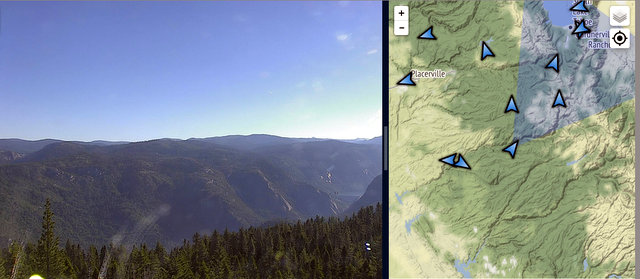
Above is the Cameras Pointed at the North Mokelumne Area
“The enhanced meteorological data we are receiving from these weather stations is bolstering our ability to forecast high fire-risk weather conditions with further granularity so that we can take swift action to protect public safety,” said PG&E CWSP Vice President Sumeet Singh. “Personnel at PG&E’s 24/7 Wildfire Safety Operations Center will use these weather stations and cameras to better monitor wildfire risks and coordinate prevention and response efforts, and the data is shared publicly and with agencies such as CAL FIRE.”
New weather stations installed in more than 35 counties
Building on the 200 weather stations it installed in 2018, PG&E has added an additional 200 weather stations in 2019 to capture localized, real-time data related to temperature, wind speeds and humidity levels. Approximately 400 new weather stations are scheduled to be installed in 2019, prioritized in areas at elevated and extreme risk for wildfires, based on the California Public Utilities Commission (CPUC) High Fire-Threat District Map.
To help protect customers and communities during extreme weather events, electric power may be shut off for public safety in an effort to prevent a wildfire. This is called a Public Safety Power Shutoff (PSPS). PG&E’s meteorologists will feed data from these new stations to the company’s Wildfire Safety Operations Center team, where it can be utilized to help inform actions such as PSPS.
Before any PSPS, PG&E will carefully review a combination of criteria including predictions of strong winds and very low humidity levels; additional weather stations will assist PG&E’s Meteorology team to better predict conditions specific to local geographic areas. Data collected by the weather stations is available to state and local agencies and the public through online sources such as the National Weather Service and MesoWest.
“These new weather stations help us monitor conditions around the clock, improving our ability to understand when and where it is necessary to take this precautionary action in the interest of public safety,” said Aaron Johnson, PG&E vice president of Electric Operations.
Counties that have already received weather stations include Alameda, Amador, Butte, Calaveras, Colusa, Contra Costa, El Dorado, Fresno, Glenn, Humboldt, Kern, Lake, Lassen, Madera, Marin, Mariposa, Mendocino, Monterey, Napa, Nevada, Placer, Plumas, San Benito, San Luis Obispo, San Mateo, Santa Barbara, Santa Clara, Santa Cruz, Shasta, Sierra, Solano, Sonoma, Tehama, Trinity, Tulare, Tuolumne and Yuba.
HD cameras being installed throughout high fire-threat areas
PG&E has installed 25 of the 100 high-definition cameras planned for this year. The company has now installed 34 HD cameras since 2018, with a goal of installing 600 new cameras by 2022 as part of the ALERTWildfire Camera Network. The ALERTWildfire Camera Network is a situational awareness tool built by the University of California, San Diego, the University of Nevada, Reno and the University of Oregon. The high-definition, pan-tilt-zoom cameras allow firefighters, first responders and companies like PG&E to confirm and monitor potential wildfires.
The system is used by fire managers and has been instrumental in tracking more than 500 fires since it was first developed in 2013. Images from the ALERTWildfire system are viewable online at www.alertwildfire.org.
Counties that have received cameras so far include Amador, Calaveras, El Dorado, Humboldt, Lake, Marin, Mariposa, Monterey, Napa, San Benito, Shasta, Sonoma, Tehama, Trinity, Yolo and Yuba.
Community Wildfire Safety Program
In addition to improving real-time monitoring and intelligence capabilities, other actions PG&E is taking as part of CWSP include putting in place new and enhanced safety measures and doing more over the long-term to strengthen the safety and resiliency of the electric grid in an effort to further reduce future wildfire risks. More information can be found at pge.com/wildfiresafety.
About PG&E
Pacific Gas and Electric Company, a subsidiary of PG&E Corporation (NYSE:PCG), is one of the largest combined natural gas and electric energy companies in the United States. Based in San Francisco, with more than 24,000 employees, the company delivers some of the nation’s cleanest energy to nearly 16 million people in Northern and Central California. For more information, visit www.pge.com/ and www.pge.com/en/about/newsroom/index.page.


