


Arnold, CA…Another storm is inbound and it will be slightly warmer than the last one. If the snow level stays low enough it should be just what the ski resorts need as a heavy base of Sierra Cement for the season. This last storm while a great way to start the season was a bit too powdery for a great base. Following The detailed forecast for West Slope Northern Sierra Nevada is the Mother Lode forecast and the Winter Storm Warnings…
Today
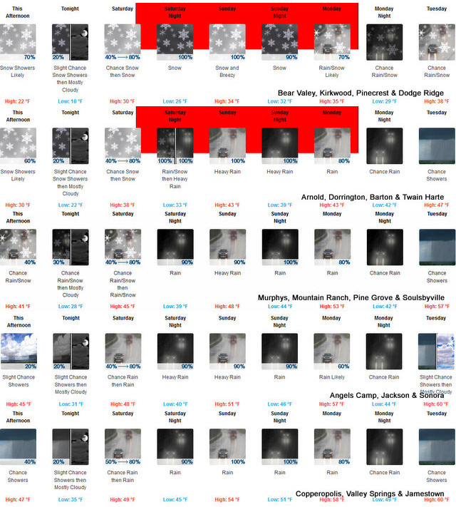
Mostly cloudy. Snow showers likely in the morning, then a chance of snow showers in the afternoon. Highs 17 to 32 higher elevations…30 to 40 lower elevations. Snow accumulation of 1 to 3 inches lower elevations…except 2 to 7 inches higher elevations. Prevailing southwest winds up to 10 mph.
Tonight
Mostly cloudy with a slight chance of snow showers in the evening, then partly cloudy after midnight. Colder. Lows 7 to 22 higher elevations…20 to 30 lower elevations. Prevailing south winds up to 10 mph.
Saturday
Mostly cloudy. A chance of snow in the afternoon. Not as cold. Highs 25 to 40 higher elevations…36 to 44 lower elevations. Prevailing south winds up to 10 mph with gusts to around 25 mph.
Saturday Night
Rain and snow. Lows 19 to 34 higher elevations…30 to 40 lower elevations. Snow accumulation up to 2 inches lower elevations…except 7 to 12 inches higher elevations. Snow level 5000 feet. Prevailing southeast winds 5 to 15 mph with gusts to around 30 mph.
Sunday
Heavy rain and snow. Not as cool. Highs 29 to 44 higher elevations…40 to 48 lower elevations. No snow accumulation lower elevations…7 to 13 inches higher elevations. Snow level 6500 feet. Prevailing south winds 10 to 20 mph with gusts to around 40 mph.
Sunday Night
Heavy rain and snow. Heavy snow accumulations possible. Lows 29 to 44.
Monday
Rain and snow likely. Moderate snow accumulations possible. Highs 34 to 49.
Monday Night
Mostly cloudy with a chance of rain and snow. Lows 27 to 42.
Tuesday And Tuesday Night
Mostly cloudy with a slight chance of rain and snow showers. Highs 36 to 51. Lows 27 to 42.
Wednesday Through Thursday
Mostly cloudy with a chance of rain and snow showers. Highs 34 to 49. Lows 27 to 42.
Detailed forecast for Motherlode
Today
Mostly cloudy with a chance of rain and snow showers. Highs 35 to 49. No snow accumulation lower elevations…up to 1 inch higher elevations. Snow level 2500 feet. Prevailing south winds up to 10 mph.
Tonight
Mostly cloudy with a slight chance of rain and snow showers in the evening, then partly cloudy after midnight. Lows 24 to 36. No snow accumulation lower elevations…up to 1 inch higher elevations. Snow level 2500 feet. Prevailing southeast winds up to 10 mph.
Saturday
Mostly cloudy. A chance of rain and snow in the afternoon. Highs 40 to 50. No snow accumulation lower elevations…up to 1 inch higher elevations. Snow level 2500 feet in the afternoon. Prevailing southeast winds up to 10 mph.
Saturday Night
Rain. Lows 32 to 46. Prevailing southeast winds 5 to 15 mph with gusts to around 30 mph.
Sunday
Heavy rain. Highs 44 to 54. Prevailing southeast winds 10 to 20 mph.
Sunday Night
Rain. Lows 40 to 52.
Monday
Rain likely. Not as cool. Highs 48 to 60.
Monday Night
Mostly cloudy with a chance of rain. Lows 39 to 51.
Tuesday And Tuesday Night
Mostly cloudy with a slight chance of rain showers. Highs 52 to 62. Lows 37 to 51.
Wednesday Through Thursday
Mostly cloudy with a chance of rain showers. Highs 46 to 58. Lows 37 to 49.
Winter Storm Warning
URGENT – WINTER WEATHER MESSAGE
National Weather Service Sacramento CA
1144 AM PST Fri Nov 29 2019
…Significant Winter Storm Saturday through Monday…
.Another significant winter storm is expected to impact the region
this weekend, mainly late Saturday into Monday. Snow levels well
start out low, into the foothills of the Sierra, but will rise
quickly late Saturday into Sunday. By Sunday night and Monday the
snow levels are expected to be near or above the Sierra Nevada
pass levels.
Travelers should prepare for wintry weather this weekend. The low
snow levels will cause travel delays Saturday into Sunday. Travel
conditions could improve Sunday night and Monday as snow levels
rise to near or above the mountain passes.
CAZ069-301400-
/O.CAN.KSTO.WW.Y.0024.000000T0000Z-191129T2000Z/
/O.UPG.KSTO.WS.A.0015.191130T1800Z-191202T1200Z/
/O.NEW.KSTO.WS.W.0018.191130T2300Z-191203T0200Z/
West Slope Northern Sierra Nevada-
1144 AM PST Fri Nov 29 2019
…WINTER STORM WARNING IN EFFECT FROM 3 PM SATURDAY TO 6 PM PST
MONDAY…
* WHAT…Heavy snow expected Saturday afternoon into Monday.
Travel will be very difficult to impossible. Total snow
accumulations up to 2 feet with locally higher amounts.
* WHERE…West Slope Northern Sierra Nevada.
* WHEN…3 PM Saturday to 6 PM Monday.
* ADDITIONAL DETAILS…Snow levels 3000 to 4000 feet Saturday
rising to 6000 feet late Saturday night and early Sunday and
near or above the passes Sunday night and Monday.
PRECAUTIONARY/PREPAREDNESS ACTIONS…
A Winter Storm Warning for snow means there will be snow covered
roads and limited visibilities. Travel is not recommended while
the warning is in effect. If you must travel, keep an extra
flashlight, food and water in your vehicle in case of an
emergency.The latest road conditions for the state you are
calling from can be obtained by calling 5 1 1.
$$
Over Two Feet of Snow Above 6,500 Feet Expected From Next Warmer Storm added by admin on
View all posts by admin →