


Arnold, CA…Winter Storm Warning Continues Until 6pm, Snow Levels Remain High, Some Areas Might Even See a Bit of Sun Tomorrow! Below are the latest weather warnings & forecasts for West Slope & Mother Lode.
Detailed forecast for
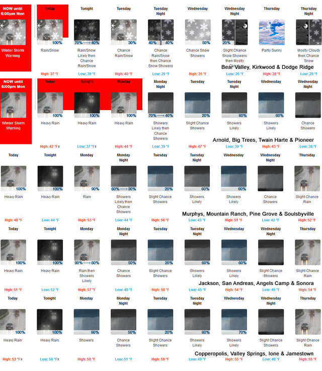
West Slope Northern Sierra Nevada
Today
Rain at lower elevations…and rain and snow at higher elevations. Not as cool. Highs 32 to 47 higher elevations…44 to 52 lower elevations. No snow accumulation lower elevations…3 to 9 inches higher elevations. Snow level 7500 feet. Prevailing southeast winds 5 to 15 mph with gusts to around 35 mph…except south 15 to 30 mph over ridges.
Tonight
Mostly cloudy. At lower elevations, a chance of rain showers. At higher elevations, rain and snow showers likely in the evening, then a chance of rain and snow showers after midnight. Lows 25 to 40 higher elevations…36 to 46 lower elevations. No snow accumulation lower elevations…2 to 4 inches higher elevations. Snow level above 8000 feet. Prevailing southeast winds up to 10 mph.
Tuesday
Mostly cloudy. A slight chance of rain showers at lower elevations…and a slight chance of rain and snow showers at higher elevations. Not as cool. Highs 34 to 49 higher elevations…47 to 55 lower elevations. No snow accumulation lower elevations…up to 1 inch higher elevations. Snow level above 8000 feet. Prevailing east winds up to 10 mph.
Tuesday Night
Mostly cloudy with a chance of rain and snow showers. Lows 23 to 38 higher elevations…35 to 45 lower elevations. No snow accumulation lower elevations…up to 2 inches higher elevations. Snow level 7500 feet. Prevailing east winds up to 10 mph.
Wednesday
Mostly cloudy with a chance of rain and snow showers. Highs 29 to 44 higher elevations…42 to 50 lower elevations. No snow accumulation lower elevations…up to 3 inches higher elevations. Snow level 7000 feet. Prevailing northeast winds up to 10 mph in the morning becoming light.
Wednesday Night
Mostly cloudy with a slight chance of rain and snow showers. Lows 25 to 40.
Thursday
Mostly cloudy. Highs 35 to 50.
Thursday Night
Mostly cloudy with a slight chance of rain and snow. Lows 27 to 42.
Friday
Mostly cloudy with a chance of rain and snow. Breezy. Highs 33 to 48.
Friday Night And Saturday
Heavy rain and snow. Breezy. Heavy snow accumulations possible. Lows 26 to 41. Highs 30 to 45.
Saturday Night
Mostly cloudy with a chance of rain and snow. Colder. Lows 22 to 37.
Sunday
Mostly cloudy with a slight chance of rain and snow. Highs 32 to 47.
Detailed forecast for
Motherlode
Today
Rain. Highs 48 to 58. Prevailing southeast winds 5 to 15 mph.
Tonight
Mostly cloudy with a chance of rain showers. Lows 39 to 51. Prevailing east winds up to 10 mph.
Tuesday
Mostly cloudy with a slight chance of rain showers. Highs 53 to 61. Prevailing east winds up to 10 mph in the morning becoming light.
Tuesday Night
Mostly cloudy with a chance of rain showers. Lows 38 to 50. Prevailing east winds up to 10 mph.
Wednesday
Mostly cloudy with a chance of rain showers. Highs 46 to 56. Prevailing east winds up to 10 mph in the morning becoming light.
Wednesday Night
Mostly cloudy with a slight chance of rain showers. Lows 38 to 48.
Thursday
Mostly cloudy with a slight chance of rain. Highs 48 to 58.
Thursday Night
Mostly cloudy with a slight chance of rain. Lows 40 to 52.
Friday
Mostly cloudy with rain. Highs 47 to 59.
Friday Night And Saturday
Rain. Lows 40 to 50. Highs 44 to 56.
Saturday Night
Mostly cloudy with a chance of rain. Colder. Lows 35 to 45.
Sunday
Mostly cloudy with a slight chance of rain. Highs 47 to 57.
Winter Storm Warning
URGENT – WINTER WEATHER MESSAGE
National Weather Service Sacramento CA
310 AM PST Mon Dec 2 2019
CAZ069-030200-
/O.CON.KSTO.WS.W.0018.000000T0000Z-191203T0200Z/
West Slope Northern Sierra Nevada-
310 AM PST Mon Dec 2 2019
…WINTER STORM WARNING REMAINS IN EFFECT UNTIL 6 PM PST THIS
EVENING ABOVE 6500 FEET…
* WHAT…Heavy snow occurring. Plan on difficult travel conditions
over the higher passes. Additional snow accumulations of 3 to 6
inches, with localized amounts up to a foot, are expected.
* WHERE…West Slope Northern Sierra Nevada.
* WHEN…Until 6 PM today.
* ADDITIONAL DETAILS…Be prepared for significant reductions in
visibility at times.
PRECAUTIONARY/PREPAREDNESS ACTIONS…
A Winter Storm Warning for snow means there will be snow covered
roads and limited visibilities. Travel is not recommended while
the warning is in effect. If you must travel, keep an extra
flashlight, food and water in your vehicle in case of an
emergency.The latest road conditions for the state you are
calling from can be obtained by calling 5 1 1.
$$
Winter Storm Warning Continues Until 6pm, Snow Levels Remain High, Some Areas Might Even See a Bit of Sun Tomorrow! added by admin on
View all posts by admin →