


Arnold, CA…Detailed forecast for West Slope Northern Sierra Nevada. Today Mostly sunny. Windy. Highs 26 to 41 higher elevations… 43 to 51 lower elevations. Prevailing northeast winds 15 to 30 mph with gusts to around 70 mph. Over ridges, prevailing northeast winds 25 to 45 mph with local gusts to around 60 mph increasing to 35 to 55 mph with local gusts to around 75 mph in the afternoon. Tonight Clear, breezy. Lows 17 to 32 higher elevations…32 to 40 lower elevations. Prevailing northeast winds 10 to 25 mph with gusts to around 60 mph. Over ridges, prevailing northeast winds 35 to 50 mph with local gusts to around 70 mph decreasing to 25 to 40 mph with local gusts to around 55 mph after midnight.
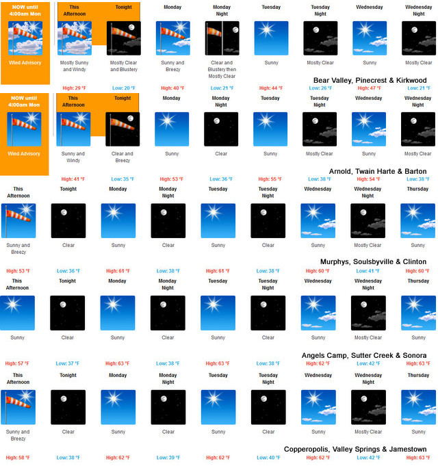
Monday Sunny, breezy. Not as cool. Highs 36 to 51 higher elevations…52 to 62 lower elevations. Prevailing northeast winds 10 to 25 mph with local gusts to around 45 mph.
Monday Night Clear. Lows 18 to 33 higher elevations…33 to 41 lower elevations. Prevailing northeast winds 10 to 20 mph with local gusts to around 35 mph.
Tuesday Sunny. Not as cool. Highs 40 to 55 higher elevations… 54 to 64 lower elevations. Prevailing northeast winds 10 to 20 mph.
Tuesday Night Clear. Lows 24 to 39.
Wednesday Mostly sunny. Highs 45 to 60.
Wednesday Night Mostly clear. Lows 24 to 39.
Thursday Sunny. Highs 44 to 59.
Thursday Night Partly cloudy with a chance of rain and snow showers. Lows 25 to 40.
Friday Mostly cloudy with a chance of rain and snow showers. Highs 39 to 54.
Friday Night Partly cloudy with a slight chance of snow showers. Colder. Lows 22 to 37.
Saturday Mostly sunny. Highs 40 to 55.
Detailed forecast for
Mother lode
Today Sunny, breezy. Highs 49 to 61. Prevailing northeast winds 5 to 15 mph increasing to 15 to 25 mph in the afternoon. Gusts up to 45 mph.
Tonigh tClear. Lows 34 to 42. Prevailing northeast winds up to 15 mph with gusts to around 30 mph.
Monday Sunny, warmer. Highs 58 to 68. Prevailing north winds up to 10 mph.
Monday Night Clear. Lows 36 to 42. Prevailing northeast winds up to 10 mph.
Tuesday Sunny. Highs 59 to 67. Prevailing northeast winds up to 10 mph.
Tuesday Night Clear. Lows 35 to 43.
Wednesday Mostly sunny. Highs 57 to 65.
Wednesday Night Mostly clear. Lows 37 to 45.
Thursday Sunny. Highs 57 to 65.
Thursday Night And Friday Partly cloudy with a slight chance of rain showers. Lows 37 to 45. Highs 51 to 61.
Friday Night And Saturday Mostly clear. Lows 34 to 42. Highs 54 to 62.
Wind Advisory
URGENT – WEATHER MESSAGE…CORRECTED
National Weather Service Sacramento CA
635 AM PST Sun Feb 9 2020
…Strong North to East Wind Today…
.Period of strong north to east wind expected over portions of
interior Northern California today into tonight. Highest wind
speeds are forecast for later this morning into the afternoon in
the Delta area, and along the west side of the Sacramento Valley
extending into the Coastal Range. Areas of strong wind are also
possible over ridges and through favorably oriented canyons of
the Sierra Nevada. Wind speeds decrease tonight in the Central
Valley, but remain windy in the mountains into Monday morning.
CAZ063-064-068-069-100615-
/O.CON.KSTO.WI.Y.0003.000000T0000Z-200210T1200Z/
Mountains Southwestern Shasta County to Northern Lake County-
Clear Lake/Southern Lake County-Western Plumas County/Lassen Park-
West Slope Northern Sierra Nevada-
Including the cities of Alder Springs, Lakeport, Chester, Quincy,
and Blue Canyon
635 AM PST Sun Feb 9 2020
…WIND ADVISORY REMAINS IN EFFECT UNTIL 4 AM PST MONDAY…
* WHAT…North to east wind 20 to 40 mph. Local wind gusts up to
60 mph, possibly higher over ridges and through favorably
oriented canyons.
* WHERE…Coastal Range from Western Shasta County to Lake
County, Western Plumas County, and West Slopes of the Northern
Sierra Nevada.
* WHEN…In effect until 4 AM PST Monday.
* IMPACTS…Gusty wind could blow around unsecured objects. Tree
limbs could be blown down and power outages may result.
Outdoor recreational activities could be impacted. Difficult
driving conditions for small and high profile vehicles.
PRECAUTIONARY/PREPAREDNESS ACTIONS…
Use extra caution when driving, especially if operating a high
profile vehicle. Secure outdoor objects.
&&
$$
As Pooh Would Say a Blustery Start to Our Weather Week for the West Slope & Mother Lode. added by admin on
View all posts by admin →