

Arnold, CA…Detailed forecast from NWS Sacramento for West Slope Northern Sierra Nevada. Today, Snow showers. Highs 21 to 36 higher elevations…32 to 42 lower elevations. Snow accumulation of 2 to 5 inches. Prevailing southwest winds up to 10 mph with gusts to around 25 mph. Tonight, Mostly cloudy in the evening then clearing. At lower elevations, a slight chance of snow showers in the evening. At higher elevations, a chance of snow showers in the evening, then a slight chance of snow showers after midnight. Lows 12 to 27 higher elevations…23 to 31 lower elevations. Little or no snow accumulation lower elevations…up to 1 inch higher elevations. Prevailing north winds up to 10 mph shifting to the northeast after midnight.
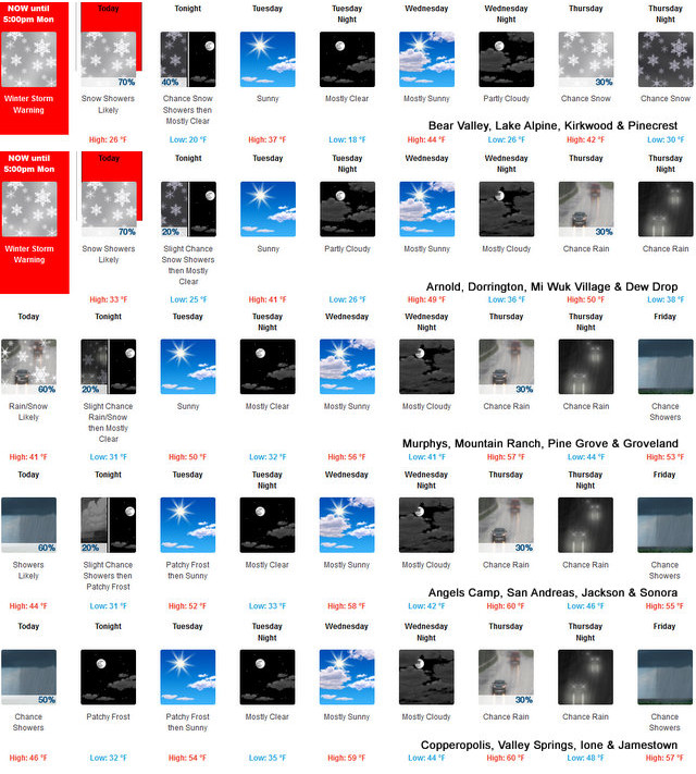

Tuesday
Mostly sunny. Not as cool. Highs 31 to 46 higher elevations…41 to 51 lower elevations. Prevailing east winds up to 10 mph shifting to the southwest in the afternoon.
Tuesday Night
Mostly clear. Lows 14 to 29 higher elevations… 25 to 33 lower elevations. Prevailing west winds up to 10 mph shifting to the east after midnight.
Wednesday
Mostly sunny in the morning then becoming partly cloudy. Not as cool. Highs 37 to 52 higher elevations…47 to 57 lower elevations. Prevailing east winds up to 10 mph shifting to the southwest in the afternoon.
Wednesday Night
Mostly cloudy. Lows 25 to 40.
Thursday
Mostly cloudy with a chance of rain and snow. Highs 39 to 54.
Thursday Night
Mostly cloudy with a chance of rain and snow. Lows 27 to 42.
Friday
Mostly cloudy with a chance of rain and snow showers. Highs 35 to 50.
Friday Night
Mostly cloudy with a chance of rain and snow showers. Colder. Lows 20 to 35.
Saturday
Partly cloudy with a slight chance of rain and snow showers. Highs 35 to 50.
Saturday Night
Partly cloudy with a slight chance of snow showers. Lows 19 to 34.
Sunday
Partly cloudy with a slight chance of snow showers. Highs 36 to 51.
Detailed forecast for Motherlode. Today, Mostly cloudy. Rain and snow showers likely. Highs 37 to 49. No snow accumulation lower elevations…1 to 3 inches higher elevations. Snow level 2500 feet. Prevailing south winds up to 10 mph shifting to the southwest in the afternoon.
Tonight
Mostly clear. A slight chance of rain and snow showers in the evening. Patchy frost after midnight. Lows 26 to 36. Snow level 2500 feet. Prevailing north winds up to 10 mph shifting to the northeast after midnight.
Tuesday
Patchy frost in the morning. Mostly sunny. Not as cool. Highs 46 to 56. Prevailing east winds up to 10 mph shifting to the southwest in the afternoon.
Tuesday Night
Mostly clear. Lows 28 to 36. Light winds.
Wednesday
Mostly sunny in the morning then becoming partly cloudy. Highs 53 to 61. Prevailing east winds up to 10 mph shifting to the southwest in the afternoon.
Wednesday Night
Mostly cloudy. Lows 37 to 45.
Thursday
Mostly cloudy with a chance of rain. Highs 51 to 63.
Thursday Night
Mostly cloudy with a chance of rain. Lows 39 to 49.
Friday
Mostly cloudy with a chance of rain showers. Highs 49 to 59.
Friday Night
Partly cloudy with a slight chance of rain showers. Colder. Lows 33 to 43.
Saturday
Partly cloudy with a slight chance of rain showers. Highs 49 to 59.
Saturday Night And Sunday
Mostly clear. Lows 32 to 40. Highs 49 to 60.
Sun Returns to West Slope & Mother Lode Tomorrow & Wednesday! added by admin on
View all posts by admin →