


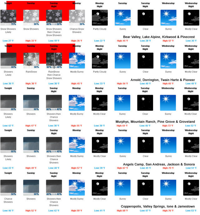
Arnold, CA…Well Ladies, Gents, Lads & Lasses the next few days looks to be this year’s “Snow on the Dogwoods” storm. The forecasts, winter storm warning and more are below. The detailed forecast for West Slope Northern Sierra Nevada. Tonight, Mostly cloudy. At lower elevations, a chance of rain showers in the evening, then rain and snow showers likely after midnight. At higher elevations, a chance of rain and snow showers in the evening, then rain and snow showers likely after midnight. Colder. Lows 21 to 35 higher elevations…32 to 40 lower elevations. No snow accumulation lower elevations…up to 3 inches higher elevations. Snow level 6500 feet decreasing to 5500 feet after midnight. Prevailing south winds 10 to 20 mph with gusts to around 40 mph…except southwest 20 to 30 mph over ridges.

Sunday
Rain and snow showers in the morning, then snow showers, rain showers and a slight chance of thunderstorms in the afternoon. Highs 27 to 42 higher elevations…37 to 47 lower elevations. Snow accumulation up to 2 inches lower elevations… Except 5 to 10 inches higher elevations. Snow level 5000 feet. Prevailing south winds 5 to 15 mph with gusts to around 30 mph.
Sunday Night
Mostly cloudy. Snow showers, rain showers and a slight chance of thunderstorms in the evening, then a chance of rain and snow showers after midnight. Colder. Lows 16 to 31 higher elevations…29 to 37 lower elevations. Little or no snow accumulation lower elevations…3 to 6 inches higher elevations. Snow level 4500 feet. Prevailing south winds up to 15 mph.
Monday
Mostly cloudy. A slight chance of snow showers in the morning, then a slight chance of rain and snow showers in the afternoon. Not as cool. Highs 30 to 45 higher elevations…43 to 53 lower elevations. Snow level 4000 feet. Prevailing southwest winds up to 15 mph.
Monday Night
Mostly clear. Lows 17 to 32 higher elevations… 29 to 39 lower elevations. Prevailing west winds up to 10 mph shifting to the northeast after midnight.
Tuesday
Sunny. Not as cool. Highs 46 to 61.
Tuesday Night
Clear. Lows 28 to 43.
Wednesday
Sunny, warmer. Highs 56 to 71.
Wednesday Night Through Thursday Night
Mostly clear. Lows 37 to 52. Highs 59 to 74.
Friday And Friday Night
Partly cloudy. Highs 64 to 79. Lows 39 to 54.
Saturday
Mostly sunny. Highs 59 to 74.
Detailed forecast for Motherlode
Tonight
Cloudy. A chance of rain showers in the evening, then rain showers likely after midnight. Colder. Lows 35 to 47. Prevailing south winds up to 15 mph.
Sunday
Rain showers in the morning, then rain showers and a slight chance of thunderstorms in the afternoon. Highs 42 to 54. Prevailing south winds up to 15 mph.
Sunday Night
Mostly cloudy. Rain showers and a slight chance of thunderstorms in the evening, then a chance of rain showers after midnight. Lows 33 to 43. Prevailing south winds up to 10 mph.
Monday
Mostly cloudy in the morning, then partly cloudy with a slight chance of rain showers in the afternoon. Not as cool. Highs 49 to 61. Prevailing southwest winds up to 10 mph.
Monday Night
Mostly clear. Lows 34 to 42. Prevailing west winds up to 10 mph shifting to the northeast after midnight.
Tuesday
Sunny, warmer. Highs 61 to 73.
Tuesday Night
Clear. Lows 41 to 49.
Wednesday
Sunny, warmer. Highs 70 to 80.
Wednesday Night Through Saturday
Mostly clear. Lows 47 to 58. Highs 70 to 85.
Winter Storm Warning
URGENT – WINTER WEATHER MESSAGE
National Weather Service Sacramento CA
236 PM PDT Sat Apr 24 2021
…Mountain Snow and Travel Impacts Late Tonight into Monday
Morning…
.A late season storm will bring periods of heavy snow to the
southern Cascades and northern Sierra beginning tonight and
continuing into early Monday. The heaviest snow is expected on
Sunday with the majority of accumulation for elevations above
4500 to 5500 feet. Lighter accumulations are possible down to
3500 feet Sunday and Monday mornings. Mountain travel is not
recommended during the warning period. If you must travel, be
prepared for winter driving conditions, significant travel
delays, and chain controls.
CAZ068-069-251600-
/O.CON.KSTO.WS.W.0006.210425T0600Z-210426T1800Z/
Western Plumas County/Lassen Park-
West Slope Northern Sierra Nevada-
236 PM PDT Sat Apr 24 2021
…WINTER STORM WARNING REMAINS IN EFFECT FROM 11 PM THIS EVENING
TO 11 AM PDT MONDAY ABOVE 4500 FEET…
* WHAT…Heavy snow expected. Travel will be very difficult to
impossible. Total snow accumulations of 8 to 14 inches, with
localized amounts up to 2 feet, are expected.
* WHERE…Western Plumas County/Lassen Park and West Slope
Northern Sierra Nevada.
* WHEN…11 PM today to 11 AM Monday.
* ADDITIONAL DETAILS…Be prepared for significant reductions in
visibility at times due to breezy winds along with chain
controls and significant travel delays.
PRECAUTIONARY/PREPAREDNESS ACTIONS…
A Winter Storm Warning for snow means there will be snow covered
roads and limited visibilities. Travel is not recommended while
the warning is in effect. If you must travel, keep an extra
flashlight, food and water in your vehicle in case of an
emergency.The latest road conditions for the state you are
calling from can be obtained by calling 5 1 1.
$$
Is this 2021’s “Snow on the Dogwoods” Storm? added by admin on
View all posts by admin →
Pingback: Is this 2021’s “Snow on the Dogwoods” Storm? - EZpaperz