


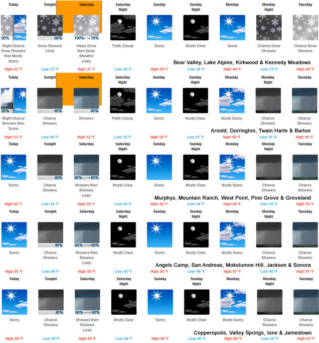
Arnold, CA…Detailed forecast from the National Weather Service for West Slope Northern Sierra Nevada. Today Mostly cloudy in the morning then clearing. At higher elevations, patchy dense fog early in the morning, a chance of rain and snow showers in the morning. At lower elevations, a chance of rain showers in the morning, patchy dense fog until late afternoon. Not as cool. Highs 36 to 51 higher elevations… 48 to 62 lower elevations. Snow level 5500 feet in the morning. Prevailing south winds 5 to 15 mph with gusts to around 30 mph.
Tonight
Mostly cloudy. In the valleys, patchy dense fog in the evening. At lower elevations, a chance of rain showers. At higher elevations, a chance of rain and snow showers. Lows 25 to 39 higher elevations…35 to 45 lower elevations. No snow accumulation lower elevations…up to 2 inches higher elevations. Snow level 6500 feet. Prevailing south winds 5 to 15 mph with gusts to around 35 mph. Over ridges, prevailing southwest winds 15 to 30 mph increasing to 30 to 40 mph with gusts to around 55 mph after midnight.
Saturday
At lower elevations, rain showers. At higher elevations, heavy rain and snow showers in the morning, then rain and snow showers likely in the afternoon. Breezy. Highs 31 to 46 higher elevations…42 to 54 lower elevations. No snow accumulation lower elevations…4 to 9 inches higher elevations. Snow level 5500 feet increasing to 6500 feet in the afternoon. Prevailing southwest winds 10 to 25 mph with gusts to around 40 mph. Over ridges, prevailing southwest winds 30 to 50 mph increasing to 40 to 55 mph with gusts to around 75 mph in the afternoon.
Saturday Night
Mostly cloudy in the evening then clearing. Colder. Lows 20 to 35 higher elevations…32 to 42 lower elevations. Prevailing southwest winds 5 to 15 mph with gusts to around 30 mph shifting to the southeast after midnight. Over ridges, prevailing southwest winds 25 to 35 mph decreasing to 15 to 25 mph after midnight.
Sunday
Mostly sunny. Not as cool. Highs 43 to 58 higher elevations…55 to 67 lower elevations. Prevailing southeast winds up to 10 mph shifting to the southwest in the afternoon. Over ridges, prevailing southwest winds 15 to 25 mph.
Sunday Night
Mostly clear. Lows 27 to 42.
Monday
Mostly sunny. Highs 46 to 61.
Monday Night And Tuesday
Mostly cloudy with a chance of rain and snow showers. Lows 29 to 44. Highs 42 to 57.
Tuesday Night
Mostly cloudy. Colder. Lows 26 to 41.
Wednesday
Partly cloudy. Not as cool. Highs 46 to 61.
Wednesday Night
Partly cloudy with a slight chance of rain showers. Lows 30 to 45.
Thursday
Mostly cloudy with a chance of rain and snow showers. Highs 44 to 59.
Detailed forecast for
Motherlode
Today
Patchy fog in the morning. Mostly cloudy with a slight chance of rain showers in the morning, then mostly sunny in the afternoon. Warmer. Highs 56 to 68. Prevailing southwest winds up to 10 mph.
Tonight
Partly cloudy in the evening then becoming mostly cloudy. A chance of rain showers. Lows 40 to 50. Prevailing southwest winds up to 10 mph shifting to the southeast after midnight.
Saturday
Rain showers. Highs 49 to 63. Prevailing south winds 5 to 15 mph.
Saturday Night
Mostly clear. Lows 37 to 45. Prevailing south winds up to 10 mph in the evening becoming light.
Sunday
Sunny, warmer. Highs 61 to 71. Light winds becoming southwest up to 10 mph in the afternoon.
Sunday Night
Mostly clear. Lows 38 to 46.
Monday
Mostly sunny. Highs 59 to 69.
Monday Night And Tuesday
Mostly cloudy with a chance of rain showers. Lows 41 to 51. Highs 54 to 69.
Tuesday Night And Wednesday
Partly cloudy. Lows 38 to 46. Highs 54 to 69.
Wednesday Night
Partly cloudy with a slight chance of rain showers. Lows 41 to 49.
Thursday
Mostly cloudy with a chance of rain showers. Highs 57 to 67.
Aprils Showers Continue, May Flowers on the Way! Beautiful Weather Forecasted for Easter added by admin on
View all posts by admin →