


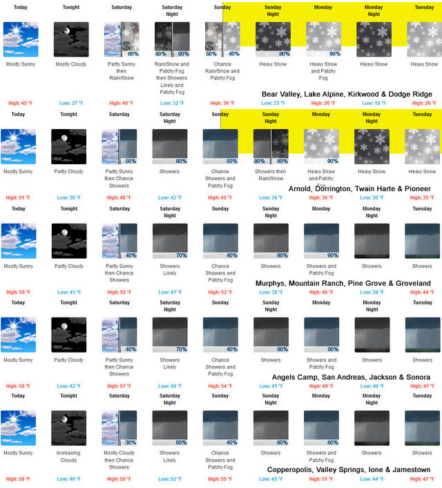
Arnold, CA…The Latest Winter Storm Watch from the National Weather Service in Sacramento. Heavy snow possible. Total snow accumulations of 2 to 4 feet possible above 4000 feet. Winds could gust as high as 40 to 50 mph. From Sunday afternoon through late Tuesday night.
Winter Storm Watch
URGENT – WINTER WEATHER MESSAGE
National Weather Service Sacramento CA
130 AM PDT Fri Nov 4 2022
CAZ013-014-068-069-042300-
/O.CON.KSTO.WS.A.0003.221106T2000Z-221109T1200Z/
Shasta Lake Area / Northern Shasta County-
Burney Basin / Eastern Shasta County-
Western Plumas County/Lassen Park-
West Slope Northern Sierra Nevada-
Including the cities of Shasta Dam, Burney, Chester, Quincy,
and Blue Canyon
130 AM PDT Fri Nov 4 2022
…WINTER STORM WATCH REMAINS IN EFFECT FROM SUNDAY AFTERNOON
THROUGH LATE TUESDAY NIGHT…
* WHAT…Heavy snow possible. Total snow accumulations of 2 to 4
feet possible above 4000 feet. Winds could gust as high as 40
to 50 mph.
* WHERE…Shasta Lake Area / Northern Shasta County, Burney Basin
/ Eastern Shasta County, Western Plumas County/Lassen Park and
West Slope Northern Sierra Nevada including Interstate 80 and
Highway 50.
* WHEN…From Sunday afternoon through late Tuesday night.
* IMPACTS…Travel could be very difficult to impossible. Strong
winds could cause tree damage.
* ADDITIONAL DETAILS…Be prepared for significant reductions in
visibility with near whiteout conditions at times.
PRECAUTIONARY/PREPAREDNESS ACTIONS…
Monitor the latest forecasts for updates on this situation.
Winter Storm Watch from Sunday Afternoon Through Tuesday Night. Rain & Heavy Snow Ahead! added by admin on
View all posts by admin →