

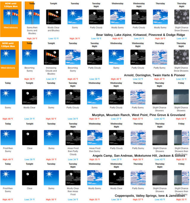
Arnold, CA…The latest forecasts from the National Weather Service for the West Slope & Mother Lode are below. Detailed forecast for West Slope Northern Sierra Nevada. Today, Sunny, breezy. Highs 20 to 35 higher elevations…33 to 47 lower elevations. Prevailing east winds 15 to 25 mph with gusts to around 40 mph. Tonight, Clear, windy. Lows 7 to 22 higher elevations…21 to 31 lower elevations. Prevailing northeast winds 15 to 30 mph with gusts to around 50 mph.

Tuesday
Sunny. Not as cool. Highs 32 to 47 higher elevations… 44 to 54 lower elevations. Prevailing northeast winds 10 to 20 mph with gusts to around 35 mph.
Tuesday Night
Mostly clear. Lows 16 to 31 higher elevations… 28 to 36 lower elevations. Prevailing northeast winds up to 10 mph.
Wednesday
Mostly sunny. Not as cool. Highs 36 to 50 higher elevations…47 to 55 lower elevations. Prevailing east winds up to 10 mph shifting to the south in the afternoon.
Wednesday Night
Partly cloudy. Lows 20 to 35.
Thursday
Partly cloudy. Highs 38 to 53.
Thursday Night And Friday
Mostly cloudy with a slight chance of rain and snow showers. Lows 24 to 39. Highs 34 to 49.
Friday Night
Mostly cloudy. Colder. Lows 21 to 36.
Saturday
Partly cloudy. Not as cool. Highs 39 to 54.
Saturday Night
Mostly cloudy with a slight chance of rain and snow showers. Lows 23 to 38.
Sunday
Mostly cloudy with a chance of rain and snow showers. Highs 30 to 45.
Detailed forecast for Motherlode
Today
Widespread frost early in the morning. Sunny. Not as cool. Highs 43 to 53. Prevailing northeast winds up to 10 mph shifting to the north in the afternoon. Gusts up to 30 mph.
Tonight
Clear. Lows 27 to 33. Prevailing northeast winds 5 to 15 mph with gusts to around 30 mph.
Tuesday
Sunny. Highs 47 to 55. Prevailing east winds up to 10 mph shifting to the southwest in the afternoon.
Tuesday Night
Mostly clear. Lows 31 to 37. Light winds becoming east up to 10 mph after midnight.
Wednesday
Areas of frost in the morning. Mostly sunny. Highs 51 to 57. Prevailing east winds up to 10 mph in the morning becoming light.
Wednesday Night
Mostly clear. Lows 33 to 39.
Thursday
Mostly cloudy. Highs 52 to 60.
Thursday Night And Friday
Mostly cloudy with a slight chance of rain showers. Lows 37 to 45. Highs 48 to 58.
Friday Night And Saturday
Mostly cloudy. Lows 35 to 41. Highs 53 to 61.
Saturday Night
Mostly cloudy with a slight chance of rain showers. Lows 37 to 45.
Sunday
Mostly cloudy with a chance of rain showers. Highs 44 to 56.
Wind Advisory
URGENT – WEATHER MESSAGE
National Weather Service Sacramento CA
200 AM PST Mon Jan 30 2023
CAZ015>018-063-066-068-069-302100-
/O.CON.KSTO.WI.Y.0006.000000T0000Z-230130T2100Z/
Northern Sacramento Valley-Central Sacramento Valley-
Southern Sacramento Valley-Carquinez Strait and Delta-
Mountains Southwestern Shasta County to Western Colusa County-
Northeast Foothills/Sacramento Valley-
Western Plumas County/Lassen Park-
West Slope Northern Sierra Nevada-
Including the cities of Redding, Red Bluff, Chico, Oroville,
Marysville/Yuba City, Sacramento, Fairfield/Suisun,
Alder Springs, Paradise, Chester, Quincy, and Blue Canyon
200 AM PST Mon Jan 30 2023
…WIND ADVISORY REMAINS IN EFFECT UNTIL 1 PM PST THIS
AFTERNOON…
* WHAT…North winds 15 to 25 mph with gusts up to 45 mph. Local
gusts up to 60 mph in the mountains.
* WHERE…Portions of the Sacramento Valley, Carquinez Strait
and Delta, Mountains of Southwestern Shasta County to Western
Colusa County, Northeast Foothills/Sacramento Valley, Western
Plumas County/Lassen Park and West Slope Northern Sierra
Nevada.
* WHEN…Until 1 PM PST this afternoon.
* IMPACTS…Gusty winds could blow around unsecured objects. Tree
limbs could be blown down and a few power outages may result.
PRECAUTIONARY/PREPAREDNESS ACTIONS…
Use extra caution when driving, especially if operating a high
profile vehicle. Secure outdoor objects.
&&
Beautiful, Crisp, Sunny Weather to Start Week. Chance of Moisture Returns Thursday Night added by admin on
View all posts by admin →