


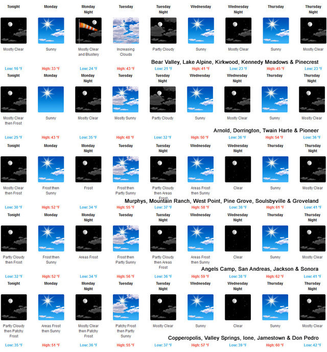
Arnold, CA…The latest from the National Weather Service for the West Slope & Mother Lode. Detailed forecast for West Slope Northern Sierra Nevada. Tonight, At higher elevations, patchy fog early in the evening. Mostly cloudy with a chance of heavy snow showers, rain showers and a slight chance of thunderstorms early in the evening, then mostly cloudy with a slight chance of snow showers late in the evening. Mostly clear after midnight. At lower elevations, patchy fog in the evening. Widespread frost late in the night. Colder. Lows 10 to 25 higher elevations…23 to 31 lower elevations. Snow level 3500 feet. Prevailing west winds up to 10 mph shifting to the northeast after midnight. Monday, Sunny. Not as cool. Highs 29 to 44 higher elevations… 42 to 52 lower elevations. Prevailing northeast winds 5 to 15 mph with gusts to around 30 mph.
Monday Night
Mostly clear. Lows 17 to 32 higher elevations… 30 to 38 lower elevations. Prevailing east winds 10 to 20 mph with gusts to around 35 mph.
Tuesday
Mostly sunny in the morning then becoming mostly cloudy. Not as cool. Highs 37 to 52 higher elevations…48 to 56 lower elevations. Prevailing east winds 5 to 15 mph shifting to the south in the afternoon.
Tuesday Night
Mostly cloudy in the evening then clearing. Lows 18 to 33 higher elevations…29 to 39 lower elevations. Prevailing southwest winds up to 10 mph shifting to the east after midnight.
Wednesday
Mostly sunny. Highs 41 to 56.
Wednesday Night
Clear. Lows 22 to 37.
Thursday And Thursday Night
Mostly clear. Highs 44 to 59. Lows 23 to 38.
Friday
Partly cloudy. Highs 43 to 58.
Friday Night Through Saturday Night
Mostly cloudy with a slight chance of rain and snow showers. Lows 22 to 37. Highs 39 to 54.
Sunday
Partly cloudy. Highs 39 to 54.
Detailed forecast for
Motherlode
Tonight
Mostly cloudy with a chance of showers and thunderstorms early in the evening, then mostly cloudy with a slight chance of rain showers late in the evening. Mostly clear after midnight. Areas of frost late in the night. Colder. Lows 27 to 35. Prevailing southeast winds up to 10 mph shifting to the northeast after midnight.
Monday
Widespread frost in the morning. Sunny. Not as cool. Highs 48 to 58. Prevailing north winds up to 10 mph.
Monday Night
Clear. Lows 33 to 39. Prevailing north winds up to 10 mph shifting to the east after midnight.
Tuesday
Mostly sunny in the morning then becoming mostly cloudy. Areas of frost in the morning. Highs 52 to 58. Prevailing east winds up to 10 mph in the morning becoming light.
Tuesday Night
Mostly clear. Lows around 36. Light winds becoming northeast up to 10 mph after midnight.
Wednesday
Mostly sunny. Highs 55 to 61.
Wednesday Night
Clear. Lows around 38.
Thursday
Sunny. Highs 58 to 64.
Thursday Night
Mostly clear. Lows 38 to 44.
Friday
Partly cloudy. Highs 59 to 65.
Friday Night Through Saturday Night
Mostly cloudy. Lows 35 to 43. Highs 54 to 62.
Sunday
Mostly sunny. Highs 54 to 62.
Sun Returns This Week for the West Slope & Mother Lode added by admin on
View all posts by admin →