

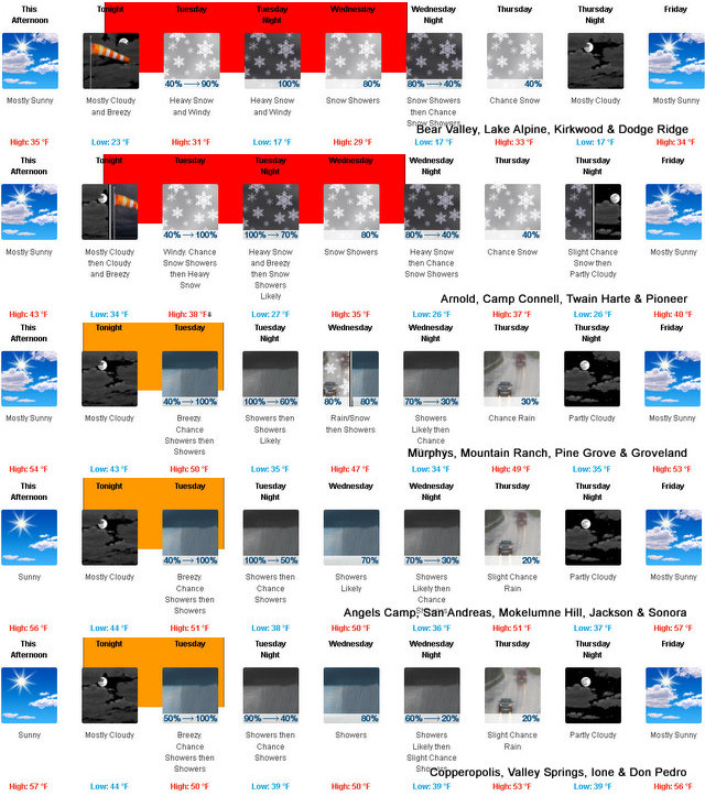
Arnold, CA…Heavy snow expected. Total snow accumulations of 2 to 4 feet. Winds gusting as high as 60 mph. From 11 PM Monday to 8 PM PDT Wednesday. Snow levels 3000 to 4000 feet, locally down to 2500 feet Tuesday and Wednesday mornings. Heaviest snow amounts above 4000 feet.

Detailed forecast for
West Slope Northern Sierra Nevada
Tonight
Mostly cloudy. A chance of snow after midnight. Windy. Lows 18 to 33 higher elevations…31 to 41 lower elevations. Prevailing south winds 5 to 15 mph increasing to 15 to 30 mph after midnight. Gusts up to 50 mph. Over ridges…prevailing southwest winds 20 to 35 mph.
Tuesday
A slight chance of heavy snow in the morning, then heavy snow showers in the afternoon. Windy. Highs 26 to 41 higher elevations…36 to 48 lower elevations. Snow accumulation of 5 to 11 inches lower elevations…except 15 to 20 inches higher elevations. Prevailing south winds 25 to 35 mph with gusts to around 60 mph.
Tuesday Night
Heavy snow showers and heavy rain showers in the evening, then snow showers likely after midnight. Windy, colder. Lows 13 to 28 higher elevations…26 to 34 lower elevations. Snow accumulation 3 to 6 inches lower elevations…except 11 to 17 inches higher elevations. Snow level 4000 feet in the evening. Prevailing south winds 15 to 30 mph with gusts to around 50 mph decreasing to 10 to 20 mph with gusts to around 35 mph after midnight. Over ridges, prevailing southwest winds 25 to 45 mph decreasing to 20 to 35 mph after midnight.
Wednesday
Mostly cloudy. A chance of snow showers in the morning, then snow showers in the afternoon. Highs 23 to 38 higher elevations…35 to 45 lower elevations. Snow accumulation 3 to 5 inches. Prevailing south winds 10 to 20 mph.
Wednesday Night
Mostly cloudy. Snow showers likely in the evening, then a chance of snow showers after midnight. Lows 11 to 26 higher elevations…23 to 33 lower elevations. Snow accumulation 3 to 5 inches. Prevailing southwest winds 5 to 15 mph shifting to the north after midnight.
Thursday
Mostly cloudy with a chance of snow. Not as cool. Highs 30 to 45.
Thursday Night
Mostly cloudy. Lows 17 to 32.
Friday
Partly cloudy. Highs 32 to 47.
Friday Night
Partly cloudy with a slight chance of snow. Lows 20 to 35.
Saturday Through Sunday Night
Mostly cloudy with a chance of rain and snow. Highs 33 to 48. Lows 21 to 36.
Monday
Mostly cloudy with a chance of snow. Highs 28 to 43.
Detailed forecast for
Motherlode
Tonight
Mostly cloudy. A slight chance of rain after midnight. A chance of rain late in the night. Lows 36 to 48. Prevailing southeast winds 10 to 20 mph.
Tuesday
Heavy rain showers in the morning, then heavy rain and snow showers in the afternoon. Windy. Highs 42 to 54. No snow accumulation lower elevations…up to 1 inch higher elevations. Prevailing south winds 15 to 30 mph with gusts to around 45 mph.
Tuesday Night
Rain showers in the evening, then rain and snow showers likely after midnight. Colder. Lows 31 to 41. No snow accumulation lower elevations…up to 1 inch higher elevations. Prevailing south winds 5 to 15 mph. Gusts up to 40 mph in the evening.
Wednesday
Mostly cloudy. A chance of rain and snow showers in the morning, then rain showers and a slight chance of thunderstorms in the afternoon. Highs 41 to 53. No snow accumulation lower elevations…up to 2 inches higher elevations. Prevailing southeast winds 5 to 15 mph.
Wednesday Night
Mostly cloudy. Rain showers likely and a slight chance of thunderstorms in the evening, then a slight chance of rain and snow showers after midnight. Lows 28 to 40. No snow accumulation lower elevations…up to 1 inch higher elevations. Prevailing southeast winds up to 10 mph in the evening becoming light.
Thursday
Mostly cloudy with a slight chance of rain. Highs 44 to 56.
Thursday Night
Partly cloudy. Lows 32 to 42.
Friday
Partly cloudy. Highs 47 to 59.
Friday Night
Partly cloudy with a slight chance of rain. Lows 34 to 42.
Saturday Through Sunday Night
Mostly cloudy with a chance of rain. Highs 47 to 61. Lows 34 to 45.
Monday
Mostly cloudy with a chance of rain and snow. Highs 44 to 56.
Winter Storm Warning
URGENT – WINTER WEATHER MESSAGE
National Weather Service Sacramento CA
152 PM PDT Mon Mar 27 2023
CAZ014-068-069-281500-
/O.CON.KSTO.WS.W.0011.230328T0600Z-230330T0300Z/
Burney Basin / Eastern Shasta County-
Western Plumas County/Lassen Park-
West Slope Northern Sierra Nevada-
Including the cities of Burney, Chester, Quincy, and Blue Canyon
152 PM PDT Mon Mar 27 2023
…WINTER STORM WARNING REMAINS IN EFFECT FROM 11 PM THIS EVENING
TO 8 PM PDT WEDNESDAY…
* WHAT…Heavy snow expected. Total snow accumulations of 2 to 4
feet. Winds gusting as high as 60 mph.
* WHERE…Burney Basin / Eastern Shasta County, Western Plumas
County/Lassen Park and West Slope Northern Sierra Nevada
Counties, including portions of Interstate 80 and Highway 50.
* WHEN…From 11 PM Monday to 8 PM PDT Wednesday.
* IMPACTS…Travel could be very difficult to impossible. The
hazardous conditions could impact the morning or evening
commute. Strong winds could cause tree damage.
* ADDITIONAL DETAILS…Snow levels 3000 to 4000 feet, locally
down to 2500 feet Tuesday and Wednesday mornings. Heaviest
snow amounts above 4000 feet and from Interstate 80 northward.
PRECAUTIONARY/PREPAREDNESS ACTIONS…
If you must travel, keep an extra flashlight, food, and water in
your vehicle in case of an emergency.
The latest road conditions for the state you are calling from can
be obtained by calling 5 1 1.
&&
$$
Another Winter Storm Heading our Way with Snow, Wind & Rain added by admin on
View all posts by admin →