

Arnold, CA…Mother Nature has been persistent in her reminders to get those fall chores done now. Soon in many parts of our coverage area she will be covered in white. At this rate a white Christmas seems almost assured. Full forecasts from the National Weather Service for the West Slope & Mother Lode are below…

Detailed forecast for
West Slope Northern Sierra Nevada
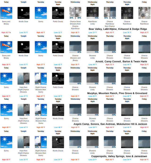
Today
Mostly sunny. Breezy. Highs 42 to 57 higher elevations… 54 to 66 lower elevations. Prevailing south winds 5 to 15 mph increasing to 15 to 25 mph in the afternoon. Gusts up to 40 mph. Over ridges…prevailing southwest winds 15 to 30 mph.
Tonight
Mostly clear. Colder. Lows 27 to 42 higher elevations…36 to 50 lower elevations. Prevailing south winds 5 to 15 mph with gusts to around 35 mph…except south 10 to 30 mph over ridges.
Tuesday
Partly cloudy in the morning then clearing. At lower elevations, a chance of rain showers. At higher elevations, a chance of rain and snow showers in the morning, then a chance of rain showers in the afternoon. Highs 42 to 57 higher elevations… 53 to 67 lower elevations. Snow level 6500 feet increasing to 7500 feet in the afternoon. Prevailing south winds 5 to 15 mph with gusts to around 30 mph.
Tuesday Night
Partly cloudy. Lows 29 to 44 higher elevations… 38 to 51 lower elevations. Prevailing southeast winds up to 10 mph.
Wednesday
Mostly cloudy. A chance of rain and snow showers in the afternoon. Breezy. Highs 42 to 57 higher elevations…55 to 65 lower elevations. Snow level 6500 feet. Prevailing southeast winds up to 10 mph increasing to south 15 to 25 mph in the afternoon.
Wednesday Night
Rain and snow showers likely. Lows 32 to 47.
Thursday
Mostly cloudy with a chance of rain and snow showers. Highs 45 to 60.
Thursday Night Through Saturday
Mostly cloudy with a chance of rain and snow showers. Lows 31 to 46. Highs 42 to 57.
Saturday Night
Partly cloudy with a slight chance of rain and snow showers. Lows 28 to 43.
Sunday
Mostly sunny. Not as cool. Highs 44 to 59.
Detailed forecast for
Motherlode
Today
Partly cloudy in the morning then becoming mostly sunny. Highs 58 to 70. Prevailing southeast winds up to 10 mph shifting to the south in the afternoon.
Tonight
Mostly clear. Lows 41 to 51. Prevailing southeast winds up to 10 mph.
Tuesday
Mostly cloudy in the morning then becoming partly cloudy. A chance of rain showers. Highs 58 to 72. Prevailing east winds up to 10 mph shifting to the south in the afternoon.
Tuesday Night
Partly cloudy. Lows 43 to 51. Prevailing south winds up to 10 mph shifting to the east after midnight.
Wednesday
Mostly cloudy. A slight chance of rain showers in the morning, then a chance of rain showers in the afternoon. Highs 60 to 70. Prevailing east winds up to 10 mph shifting to the south in the afternoon.
Wednesday Night
Rain showers likely. Lows 45 to 53.
Thursday
Mostly cloudy with a chance of rain showers. Highs 59 to 69.
Thursday Night Through Saturday
Mostly cloudy with a chance of rain showers. Lows 43 to 54. Highs 54 to 67.
Saturday Night
Partly cloudy with a slight chance of rain showers. Lows 41 to 49.
Sunday
Mostly sunny. Highs 57 to 65.
Rain & Snow Returns This Week & Reminds Us Ski Season is Almost Here added by admin on
View all posts by admin →