


Arnold, CA…As this series of weather systems rolls through it will bring snow above 5,000 ft and rain below. The full forecasts from the National Weather Service for this weekend are below…
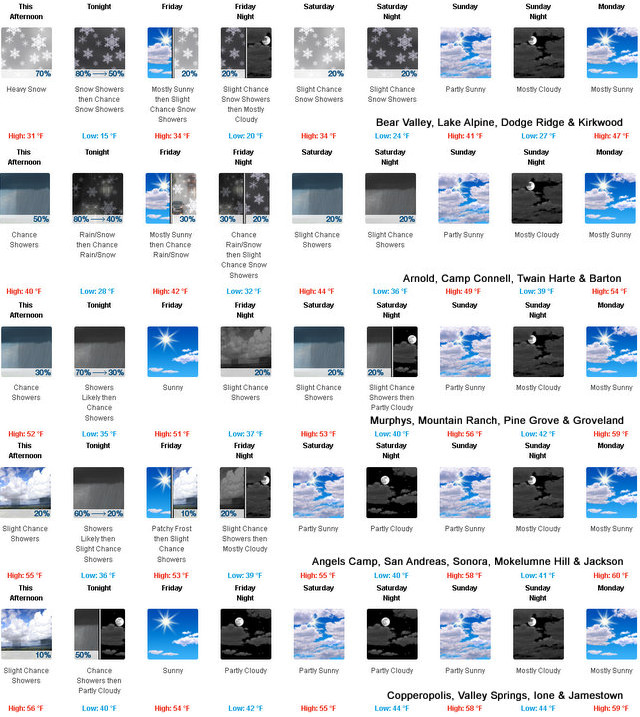

Detailed forecast for
West Slope Northern Sierra Nevada
Tonight
Colder. A chance of rain showers early in the evening. Snow showers until early morning. Rain showers likely late in the evening, then a chance of rain showers after midnight. A slight chance of snow showers late in the night. Lows 13 to 28 higher elevations…24 to 36 lower elevations. No snow accumulation lower elevations…up to 3 inches higher elevations. Snow level 5000 feet. Prevailing southwest winds up to 10 mph.
Friday
Mostly cloudy in the morning then clearing. Patchy dense fog in the morning. At lower elevations, a slight chance of rain showers in the afternoon. At higher elevations, a slight chance of snow showers in the afternoon. Highs 28 to 43 higher elevations…39 to 49 lower elevations. Prevailing northeast winds up to 10 mph shifting to the west in the afternoon.
Friday Night
Mostly cloudy. A chance of rain and snow showers in the evening, then a slight chance of rain and snow showers after midnight. Lows 17 to 32 higher elevations…27 to 39 lower elevations. Snow level 5000 feet. Prevailing west winds up to 10 mph shifting to the east after midnight.
Saturday
Mostly cloudy. A slight chance of rain and snow showers in the morning, then a chance of rain and snow showers in the afternoon. Highs 30 to 45 higher elevations…40 to 52 lower elevations. Snow level 5000 feet. Prevailing southeast winds up to 10 mph shifting to the southwest in the afternoon.
Saturday Night
Mostly cloudy with a chance of rain and snow showers. Lows 21 to 36 higher elevations…31 to 43 lower elevations. Snow level 6000 feet. Prevailing south winds up to 10 mph.
Sunday
Mostly cloudy with a slight chance of rain showers. Not as cool. Highs 39 to 54.
Sunday Night
Mostly cloudy. Lows 27 to 42.
Monday
Partly cloudy. Not as cool. Highs 45 to 60.
Monday Night And Tuesday
Mostly clear. Lows 29 to 44. Highs 48 to 63.
Tuesday Night
Partly cloudy with a slight chance of rain showers. Lows 32 to 47.
Wednesday
Mostly cloudy with a slight chance of rain showers. Highs 46 to 61.
Wednesday Night And Thursday
Mostly cloudy with a chance of rain and snow showers. Lows 29 to 44. Highs 37 to 52.
Detailed forecast for
Motherlode
Tonight
Mostly cloudy. A chance of rain showers until early morning. Lows 30 to 40. Prevailing south winds up to 10 mph in the evening becoming light.
Friday
Mostly sunny. Patchy frost in the morning. A slight chance of rain showers in the afternoon. Highs 45 to 57. Light winds becoming west up to 10 mph in the afternoon.
Friday Night
Mostly cloudy with a slight chance of rain showers. Lows 33 to 43. Light winds.
Saturday
Mostly cloudy. A slight chance of rain showers in the morning, then a chance of rain showers in the afternoon. Highs 46 to 58. Light winds becoming southwest up to 10 mph in the afternoon.
Saturday Night
Mostly cloudy. A chance of rain showers in the evening, then a slight chance of rain showers after midnight. Lows 37 to 45. Prevailing south winds up to 10 mph in the evening becoming light.
Sunday
Mostly cloudy with a slight chance of rain showers. Highs 51 to 61.
Sunday Night
Mostly cloudy. Lows 38 to 46.
Monday
Partly cloudy. Highs 55 to 63.
Monday Night And Tuesday
Mostly clear. Lows 40 to 46. Highs 59 to 67.
Tuesday Night
Partly cloudy. Lows 43 to 49.
Wednesday
Partly cloudy with a slight chance of rain showers. Highs 58 to 68.
Wednesday Night And Thursday
Mostly cloudy with a chance of rain showers. Lows 41 to 49. Highs 49 to 61.
Snow in the High Country, Rain in the Foothills as December Rolls In added by admin on
View all posts by admin →