

Arnold, CA….Winter has arrived late but for some after last year’s snow piles that isn’t completely a bad thing. Now though as the winter resorts are in need of Mother Nature’s blessings it is time for the storm door to open. The detailed forecasts for the West Slope & Mother Lode are below…

Detailed forecast for
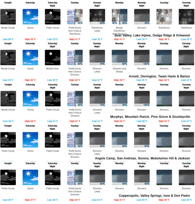
West Slope Northern Sierra Nevada
Tonight
Mostly cloudy. Lows 26 to 41 higher elevations…36 to 50 lower elevations. Prevailing east winds up to 10 mph.
Saturday
Mostly sunny. Highs 46 to 61 higher elevations… 58 to 68 lower elevations. Prevailing east winds up to 10 mph shifting to the south in the afternoon.
Saturday Night
Mostly clear. Lows 29 to 44 higher elevations… 39 to 52 lower elevations. Prevailing east winds up to 10 mph.
Sunday
Mostly cloudy. Highs 46 to 61 higher elevations…58 to 68 lower elevations. Prevailing east winds up to 10 mph.
Sunday Night
Mostly cloudy. A chance of rain and snow showers in the evening, then rain and snow showers likely after midnight. Lows 30 to 45 higher elevations…41 to 53 lower elevations. Little or no snow accumulation. Snow level above 8000 feet. Prevailing southeast winds up to 10 mph.
Monday
Rain and snow showers likely. Breezy. Highs 40 to 55.
Monday Night
Rain showers. Lows 33 to 48.
Tuesday And Tuesday Night
Rain showers and heavy snow showers. Moderate snow accumulations possible. Highs 36 to 51. Lows 31 to 46.
Wednesday
Rain and snow showers likely. Moderate snow accumulations possible. Highs 38 to 53.
Wednesday Night Through Thursday Night
Mostly cloudy with a chance of rain and snow showers. Lows 27 to 42. Highs 39 to 54.
Friday
Partly cloudy with a chance of rain and snow showers. Highs 40 to 55.
Detailed forecast for
Motherlode
Tonight
Mostly cloudy. Lows 40 to 48. Prevailing east winds up to 10 mph.
Saturday
Sunny. Highs 63 to 71. Prevailing east winds up to 10 mph in the morning becoming light.
Saturday Night
Mostly clear. Lows 42 to 50. Prevailing northeast winds up to 10 mph.
Sunday
Mostly cloudy. Highs 61 to 69. Prevailing east winds up to 10 mph shifting to the southeast in the afternoon.
Sunday Night
Mostly cloudy. A chance of rain showers in the evening, then rain showers likely after midnight. Lows 44 to 54. Prevailing east winds up to 10 mph.
Monday
Rain showers. Highs 51 to 63.
Monday Night
Rain showers and a slight chance of thunderstorms. Lows 47 to 55.
Tuesday
Rain showers. Highs 50 to 60.
Tuesday Night And Wednesday
Rain showers. Lows 42 to 52. Highs 52 to 62.
Wednesday Night And Thursday
Mostly cloudy with a chance of rain showers. Lows 40 to 48. Highs 54 to 62.
Thursday Night
Partly cloudy with a slight chance of rain showers. Lows 38 to 46.
Friday
Partly cloudy with a slight chance of rain showers. Highs 53 to 61.
Winter Arrives on Sunday & Will Stay Through Christmas added by admin on
View all posts by admin →