

Arnold, CA…This is the latest Detailed forecast from the National Weather Service for
West Slope Northern Sierra Nevada. Today, Mostly cloudy. At lower elevations, a chance of rain in the afternoon. At higher elevations, a chance of rain and snow in the afternoon. Highs 34 to 49 higher elevations…45 to 55 lower elevations. Snow level 7000 feet. Prevailing east winds up to 10 mph shifting to the south in the afternoon. Gusts up to 25 mph. Over ridges…prevailing southwest winds 5 to 15 mph increasing to 15 to 25 mph in the afternoon.
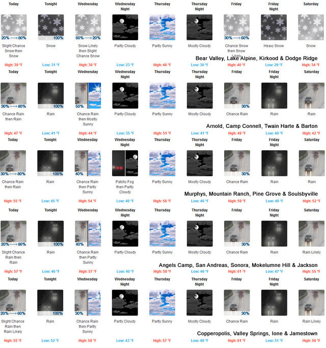

Tonight
Rain at lower elevations…and rain and snow at higher elevations. Lows 26 to 40 higher elevations…35 to 46 lower elevations. No snow accumulation lower elevations…2 to 4 inches higher elevations. Snow level above 8000 feet. Prevailing south winds 5 to 15 mph with gusts to around 35 mph…except south 10 to 35 mph over ridges.
Wednesday
Mostly cloudy. At lower elevations, rain likely in the morning, then a slight chance of rain in the afternoon. At higher elevations, rain and snow likely in the morning, then a slight chance of rain and snow in the afternoon. Highs 31 to 46 higher elevations…42 to 54 lower elevations. No snow accumulation lower elevations…up to 1 inch higher elevations. Snow level 6500 feet. Prevailing southwest winds 5 to 15 mph with gusts to around 35 mph…except southwest 10 to 30 mph over ridges.
Wednesday Night
Partly cloudy. Colder. Lows 19 to 34 higher elevations…30 to 41 lower elevations. Prevailing south winds up to 10 mph shifting to the east after midnight.
Thursday
Mostly cloudy. Not as cool. Highs 40 to 55 higher elevations…50 to 60 lower elevations. Prevailing east winds up to 10 mph.
Thursday Night
Mostly cloudy. Lows 29 to 44.
Friday
Mostly cloudy with a chance of rain. Highs 39 to 54.
Friday Night
Rain and heavy snow. Moderate snow accumulations possible. Lows 28 to 43.
Saturday And Saturday Night
Rain and snow. Moderate snow accumulations possible. Highs 33 to 48. Lows 28 to 43.
Sunday And Sunday Night
Heavy rain and snow. Moderate snow accumulations possible. Highs 33 to 48. Lows 29 to 44.
Monday
Rain and snow. Moderate snow accumulations possible. Highs 33 to 48.
Detailed forecast for
Motherlode
Today
Mostly cloudy. Patchy dense fog in the morning. A chance of rain in the afternoon. Highs 50 to 58. Light winds becoming southeast up to 10 mph in the afternoon.
Tonight
Rain. Lows 41 to 49. Prevailing southeast winds up to 10 mph.
Wednesday
Mostly cloudy. A chance of rain in the morning, then a slight chance of rain in the afternoon. Highs 48 to 60. Prevailing south winds up to 10 mph.
Wednesday Night
Partly cloudy. Patchy fog. Lows 36 to 44. Prevailing west winds up to 10 mph in the evening becoming light.
Thursday
Mostly cloudy. Highs 54 to 60. Prevailing northeast winds up to 10 mph shifting to the south in the afternoon.
Thursday Night
Mostly cloudy. Lows 41 to 49.
Friday
Mostly cloudy with a chance of rain. Highs 54 to 64.
Friday Night
Rain. Lows 41 to 51.
Saturday And Saturday Night
Rain. Highs 47 to 59. Lows 41 to 51.
Sunday And Sunday Night
Rain. Highs 47 to 57. Lows 41 to 52.
Monday
Rain likely. Highs 47 to 59.
A Bit More Moisture for the West Slope & Mother Lode added by admin on
View all posts by admin →