


Arnold, CA…Winter looks to stick around most of this week. Early March will look a lot like an early February. The latest forecasts for the West Slope and Mother Lode are below…

Detailed forecast for
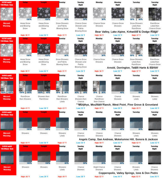
West Slope Northern Sierra Nevada
Today
Heavy snow showers and a slight chance of thunderstorms. Blowing snow. Windy. Visibility one quarter mile or less at times. Highs 17 to 32 higher elevations…27 to 39 lower elevations. Snow accumulation of 5 to 11 inches lower elevations…except 17 to 22 inches higher elevations. Prevailing southwest winds 15 to 35 mph with gusts to around 70 mph…except southwest 15 to 60 mph with gusts to around 80 mph over ridges.
Tonight
Heavy snow showers and a slight chance of thunderstorms in the evening, then heavy snow showers after midnight. Blowing snow through the night. Windy. Visibility one quarter mile or less at times. Lows 11 to 26 higher elevations… 23 to 33 lower elevations. Snow accumulation of 5 to 10 inches lower elevations…except 14 to 20 inches higher elevations. Prevailing southwest winds 20 to 30 mph with gusts to around 70 mph…except southwest 20 to 55 mph with gusts to around 80 mph over ridges.
Sunday
Heavy snow showers. Blowing snow. Breezy. Visibility one quarter mile or less at times. Highs 19 to 34 higher elevations…30 to 40 lower elevations. Snow accumulation of 4 to 9 inches. Prevailing southwest winds 15 to 25 mph with gusts to around 50 mph…except southwest 15 to 45 mph over ridges.
Sunday Night
Mostly cloudy. Heavy snow showers likely in the evening, then a chance of snow showers after midnight. Blowing snow in the evening, then patchy blowing snow after midnight. Visibility one quarter mile or less at times. Breezy. Lows 12 to 27 higher elevations…24 to 34 lower elevations. Snow accumulation 3 to 5 inches lower elevations…except 2 to 8 inches higher elevations. Prevailing southwest winds 10 to 25 mph with gusts to around 50 mph. Over ridges, prevailing southwest winds 30 to 45 mph decreasing to 25 to 35 mph after midnight. Gusts up to 60 mph over ridges.
Monday
Mostly cloudy with a chance of snow showers. Patchy blowing snow. Not as cold. Visibility one quarter mile or less at times. Highs 23 to 38 higher elevations…33 to 45 lower elevations. Snow accumulation up to 3 inches lower elevations… Except 3 to 6 inches higher elevations. Prevailing southwest winds 5 to 15 mph with gusts to around 40 mph…except southwest 10 to 30 mph over ridges.
Monday Night
Mostly cloudy with a chance of heavy rain and snow showers likely. Patchy blowing snow. Breezy. Visibility one quarter mile or less at times. Moderate snow accumulations possible. Lows 22 to 37.
Tuesday
Heavy rain and snow showers likely. Patchy blowing snow. Visibility one quarter mile or less at times. Heavy snow accumulations possible. Highs 29 to 44.
Tuesday Night
Mostly cloudy with rain and snow showers likely. Moderate snow accumulations possible. Lows 22 to 37.
Wednesday
Mostly cloudy with a chance of rain and snow showers. Highs 31 to 46.
Wednesday Night
Partly cloudy with a chance of rain and snow showers. Colder. Lows 16 to 31.
Thursday
Partly cloudy with a slight chance of snow showers. Highs 33 to 48.
Thursday Night And Friday
Mostly clear. Lows 17 to 32. Highs 37 to 52.
Detailed forecast for
Motherlode
Today
A slight chance of thunderstorms in the morning. Rain showers and snow showers through the day. A chance of thunderstorms early in the afternoon, then a slight chance of thunderstorms late in the afternoon. Highs 33 to 43 higher elevations…40 to 48 lower elevations. No snow accumulation lower elevations…3 to 5 inches higher elevations. Snow level 2500 feet. Prevailing southwest winds 10 to 20 mph.
Tonight
Rain showers, snow showers and a chance of thunderstorms in the evening, then rain showers, snow showers and a slight chance of thunderstorms after midnight. Lows 29 to 39. No snow accumulation lower elevations…2 to 4 inches higher elevations. Prevailing southwest winds 10 to 20 mph.
Sunday
Rain and snow showers likely. Not as cool. Highs 36 to 46 higher elevations…42 to 52 lower elevations. No snow accumulation lower elevations…up to 2 inches higher elevations. Prevailing south winds 5 to 15 mph.
Sunday Night
Mostly cloudy. Rain and snow showers likely in the evening, then a chance of rain and snow showers after midnight. Lows 30 to 40. No snow accumulation. Prevailing south winds 5 to 15 mph.
Monday
Mostly cloudy. A chance of rain and snow showers in the morning, then a chance of rain showers in the afternoon. Highs 39 to 49 higher elevations…44 to 54 lower elevations. Prevailing south winds up to 15 mph.
Monday Night
Mostly cloudy with a chance of rain showers. Lows 35 to 45.
Tuesday
Rain showers likely. Highs 42 to 56.
Tuesday Night And Wednesday
Mostly cloudy with a chance of rain showers. Lows 35 to 45. Highs 45 to 57.
Wednesday Night
Partly cloudy with a slight chance of rain showers. Colder. Lows 30 to 38.
Thursday
Mostly sunny. Highs 49 to 61.
Thursday Night And Friday
Clear. Lows 32 to 38. Highs 53 to 63.
Early March Weather Rolls in Like a February added by admin on
View all posts by admin →