

Arnold, CA…This highway information is the latest reported by Caltrans as of Thursday, April 4th, 2024 at 04:43 PM.
SR 4
[IN THE CENTRAL CALIFORNIA AREA]
Is closed from 0.5 mi east of the Jct of SR 207 /Mt Reba Turnoff/ to 7.2 mi west of the Jct of SR 89 /Ebbetts Pass/ (Alpine Co) – For the winter – Motorists are advised to use an alternate route
Chains are required on all vehicles except 4-wheel-drive vehicles with snow tires on all 4 wheels from 3 mi east of Murphys to 3.5 mi east of Cottage Springs (Calaveras Co)
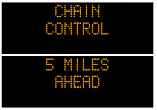
Please research chain control locations as caltrans is currently working to update chain control descriptions for consistency with internet mapping, like google maps & mapquest.
SR 26
[IN THE CENTRAL CALIFORNIA & SIERRA NEVADA]
Chains are required on all vehicles except 4-wheel-drive vehicles with snow tires on all 4 wheels from 6.5 mi east of Mokelumne Hill (Calaveras Co) to the Calaveras/Amador Co Line
Please research chain control locations as Caltrans is currently working to update chain control descriptions for consistency with internet mapping, like Google Maps & Mapquest
1-way controlled traffic 2.7 mi west of Sandy Gulch /at the South Fork of the Mokelumne River/ (Calaveras Co) 24 hrs a day 7 days a week thru 0700 hrs on 6/30/24 – Due to bridge work
1-way controlled traffic at the North Fork of the Mokelumne River /in West Point/ (Calaveras Co) 24 hrs a day 7 days a week thru 0700 hrs on 6/30/24 – Due to bridge work
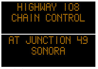
SR 49
[IN THE CENTRAL CALIFORNIA AREA]
Chains are required on all vehicles except 4-wheel-drive vehicles with snow tires on all 4 wheels from the Jct of SR 41 (Madera Co) to the Madera/Mariposa Co Line
Please research chain control locations as Caltrans is currently working to update chain control descriptions for consistency with internet mapping, like Google Maps & Mapquest
1-way controlled traffic at the Calaveras/Amador Co Line 24 hrs a day 7 days a week thru 2359 hrs on 10/4/24 – Due to bridge work
[IN THE NORTHERN CALIFORNIA AREA]
No traffic restrictions are reported for this area.
SR 88
[IN THE CENTRAL CALIFORNIA AREA & SIERRA NEVADA]
Chains are required on all vehicles except 4-wheel-drive vehicles with snow tires on all 4 wheels from 3.6 mi west of Dew Drop (Amador Co) to 5 mi west of Picketts Jct (Alpine Co)
Please research chain control locations as Caltrans is currently working to update chain control descriptions for consistency with internet mapping, like Google Maps & Mapquest
SR 108
[IN THE CENTRAL CALIFORNIA AREA & SIERRA NEVADA]
Is closed from 7.2 mi east of Strawberry (Tuolumne Co) to 7.7 mi west of the Jct US 395 (Mono Co) /Sonora Pass/ – For the winter – Motorists are advised to use an alternate route
Chains are required on all vehicles except 4-wheel-drive vehicles with snow tires on all 4 wheels from the Jct of SR 49 to 7.2 mi east of Strawberry (Tuolumne Co)
Please research chain control locations as Caltrans is currently working to update chain control descriptions for consistency with internet mapping, like Google Maps & Mapquest
[YOSEMITE NAT’L PARK] For Yosemite Nat’l Park road information call 209-372-0200
SR 120
[IN THE CENTRAL CALIFORNIA AREA & SIERRA NEVADA]
Is closed from Crane Flat to 4.5 mi west of the Jct of US 395 /Tioga Pass/ (Mono Co) – For the winter – Motorists are advised to use an alternate route
Is closed from 5.1 mi east of the south Jct of US 395 to 7.1 mi west of the Jct of US 6 (Mono Co) – For the winter – Motorists are advised to use an alternate route
Chains are required on all vehicles except 4-wheel-drive vehicles with snow tires on all 4 wheels from 2.5 mi west of Groveland to the Yosemite National Park Boundry (Tuolumne Co)
Please research chain control locations as Caltrans is currently working to update chain control descriptions for consistency with internet mapping, like Google Maps & Mapquest
[YOSEMITE NAT’L PARK]
For Yosenite Nat’l Park road information call 209-372-0200
Lowest Chain Controls of the Year! Chain Controls on Hwys 4, 26, 49, 88, 108 & 120 added by admin on
View all posts by admin →