

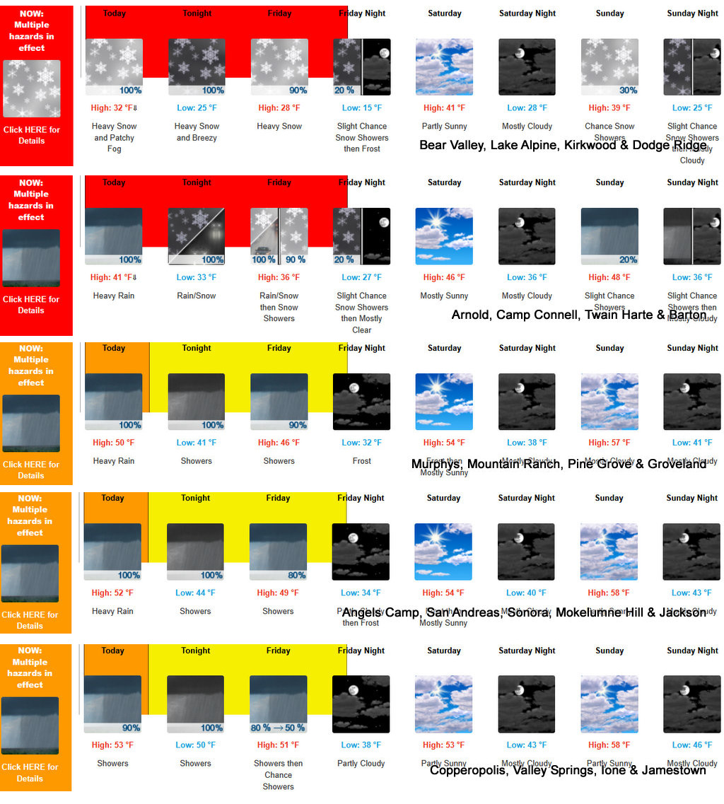
Arnold, CA…Mother Nature is upset about her lack of Valentines Day Love and is taking it out on us! From NWS Sac. “Heavy snow. Heaviest accumulations of 2 to 5 feet possible above 6000 feet with 5 to 15 inches between 4500 and 6000 feet. Winds could gust as high as 60 mph. Excessive runoff may result in flooding of rivers, creeks, streams, and other low-lying and flood-prone locations. Creeks and streams may rise out of their banks. Flooding may occur in poor drainage and urban areas. Low-water crossings may be flooded.”
ThePineTree.net Weather Sponsored By Fox Security

Winter Storm Warning
URGENT – WINTER WEATHER MESSAGE
National Weather Service Sacramento CA
846 AM PST Thu Feb 13 2025
CAZ068-069-141200-
/O.CON.KSTO.WS.W.0005.000000T0000Z-250215T0600Z/
Western Plumas County/Lassen Park-West Slope Northern Sierra
Nevada-
Including the cities of Quincy, Chester, and Blue Canyon
846 AM PST Thu Feb 13 2025
…WINTER STORM WARNING REMAINS IN EFFECT UNTIL 10 PM PST FRIDAY
ABOVE 4500 FEET…
* WHAT…Heavy snow. Heaviest accumulations of 2 to 5 feet possible
above 6000 feet with 5 to 15 inches between 4500 and 6000 feet.
Winds could gust as high as 60 mph.
* WHERE…West Slope Northern Sierra Nevada and Western Plumas
County/Lassen Park.
* WHEN…Until 10 PM PST Friday.
* IMPACTS…Very difficult travel conditions with chain controls and
potential road closures. The hazardous conditions could impact the
Thursday evening and Friday morning commutes. Heaviest snowfall
expected today with snow rates of 1-2+ inches per hour at times.
* ADDITIONAL DETAILS…Snow levels 4500 to 6000 feet throughout the
day.
PRECAUTIONARY/PREPAREDNESS ACTIONS…
Check the latest road conditions from Caltrans online at
quickmap.dot.ca.gov or dial 5 1 1.
&&
$$
For more information, visit us at www.weather.gov/sto/
Flood Watch
National Weather Service Sacramento CA
147 AM PST Thu Feb 13 2025
CAZ013-015>018-063-066>069-140015-
/O.CON.KSTO.FA.A.0003.000000T0000Z-250215T0600Z/
/00000.0.ER.000000T0000Z.000000T0000Z.000000T0000Z.OO/
Shasta Lake Area / Northern Shasta County-Northern Sacramento
Valley-Central Sacramento Valley-Southern Sacramento Valley-
Carquinez Strait and Delta-Mountains Southwestern Shasta County
to Western Colusa County-Northeast Foothills/Sacramento Valley-
Motherlode-Western Plumas County/Lassen Park-West Slope Northern
Sierra Nevada-
Including the cities of Grass Valley, Paradise, Chico, Red Bluff,
Jackson, Fairfield/Suisun, Chester, Quincy, Shasta Dam, Blue
Canyon, Alder Springs, Redding, Oroville, Marysville/Yuba City,
and Sacramento
147 AM PST Thu Feb 13 2025
…FLOOD WATCH REMAINS IN EFFECT THROUGH FRIDAY EVENING…
* WHAT…Flooding caused by excessive rainfall continues to be
possible.
* WHERE…A portion of northern California, including the following
areas, Carquinez Strait and Delta, Central Sacramento Valley,
Motherlode, Mountains Southwestern Shasta County to Western Colusa
County, Northeast Foothills/Sacramento Valley, Northern Sacramento
Valley, Shasta Lake Area / Northern Shasta County, Southern
Sacramento Valley, West Slope Northern Sierra Nevada and Western
Plumas County/Lassen Park below 4500 feet.
* WHEN…Through Friday evening.
* IMPACTS…Excessive runoff may result in flooding of rivers,
creeks, streams, and other low-lying and flood-prone locations.
Creeks and streams may rise out of their banks. Flooding may occur
in poor drainage and urban areas. Low-water crossings may be
flooded.
* ADDITIONAL DETAILS…
– Periods of moderate to heavy rainfall are expected into
tonight with rainfall totals of 1 to 2.5 inches in the Valley
and Delta and 2 to 5 inches in the foothills and mountains
below the snow line. Given very wet conditions over the past
two weeks, minor flooding impacts are expected with any
runoff that occurs. Debris flows over recent burn scars like
the Park Fire are not expected but expect increased muddy
runoff.
– http://www.weather.gov/safety/flood
PRECAUTIONARY/PREPAREDNESS ACTIONS…
You should monitor later forecasts and be alert for possible Flood
Warnings. Those living in areas prone to flooding should be prepared
to take action should flooding develop.
&&
$$
EK
NR
Winter Storm Warning Continues Until 10pm Valentines Night at 10pm. Up to 5 Feet of Snow & Flooding at Lower Elevations added by admin on
View all posts by admin →