

Arnold, CA…Since we had March last month we are calling this one Marchuary. We have a winter weather advisory from 4am Wednesday until Thursday afternoon. We may even get a dusting down to 3,000 feet. Higher elevations may see 16 inches of snow. More coming next week as well. Welcome to Marchuary.
ThePineTree.net Weather Sponsored By Fox Security

Detailed forecast for
West Slope Northern Sierra Nevada
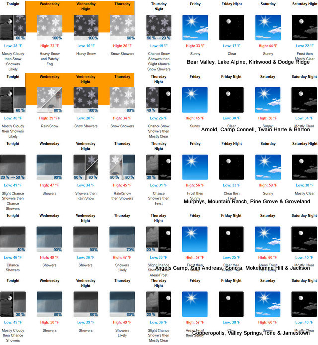
Tonight
Mostly cloudy. At higher elevations, areas of frost early in the evening, a slight chance of snow showers after midnight. A chance of rain and snow showers late in the night. At lower elevations, a slight chance of rain showers after midnight. A chance of rain showers late in the night. Lows 23 to 37 higher elevations…34 to 42 lower elevations. Snow level 6500 feet. Light winds.
Wednesday
At lower elevations, rain showers in the morning, then rain and snow showers in the afternoon. At higher elevations, rain and snow showers. Widespread fog…locally dense in the afternoon. Highs 28 to 43 higher elevations…38 to 48 lower elevations. No snow accumulation lower elevations…1 to 6 inches higher elevations. Snow level 6000 feet. Prevailing southwest winds up to 10 mph with gusts to around 25 mph.
Wednesday Night
Widespread fog…locally dense in the evening. Rain and snow showers in the evening, then snow showers after midnight. Colder. Lows 13 to 28 higher elevations…27 to 35 lower elevations. Snow accumulation up to 2 inches lower elevations…except 2 to 7 inches higher elevations. Snow level 4500 feet in the evening. Prevailing southwest winds up to 10 mph with gusts to around 25 mph.
Thursday
Snow showers. Highs 23 to 38 higher elevations… 35 to 43 lower elevations. Snow accumulation up to 3 inches. Prevailing southwest winds up to 10 mph.
Thursday Night
Mostly cloudy with a chance of snow showers in the evening, then partly cloudy with a slight chance of snow showers after midnight. Lows 12 to 27 higher elevations…23 to 33 lower elevations. No snow accumulation lower elevations…up to 1 inch higher elevations. Prevailing northwest winds up to 10 mph shifting to the northeast after midnight. Gusts up to 25 mph.
Friday
Sunny. Not as cool. Highs 35 to 50.
Friday Night
Clear. Lows 18 to 33.
Saturday
Sunny. Not as cool. Highs 42 to 57.
Saturday Night And Sunday
Mostly clear. Lows 23 to 38. Highs 44 to 59.
Sunday Night
Partly cloudy with a slight chance of rain and snow showers. Lows 26 to 41.
Monday
Mostly cloudy with a chance of rain and snow showers. Highs 37 to 52.
Monday Night
Rain and snow showers. Colder. Moderate snow accumulations possible. Lows 22 to 37.
Tuesday
Heavy rain and snow showers. Heavy snow accumulations possible. Highs 29 to 44.
Winter Weather Advisory
URGENT – WINTER WEATHER MESSAGE
National Weather Service Sacramento CA
137 PM PST Tue Mar 4 2025
CAZ014-068-069-051400-
/O.CON.KSTO.WW.Y.0005.250305T1200Z-250307T0000Z/
Burney Basin / Eastern Shasta County-Western Plumas County/Lassen
Park-West Slope Northern Sierra Nevada-
Including the cities of Blue Canyon, Burney, Chester, and Quincy
137 PM PST Tue Mar 4 2025
…WINTER WEATHER ADVISORY REMAINS IN EFFECT FROM 4 AM WEDNESDAY TO
4 PM PST THURSDAY ELEVATIONS ABOVE 4000 FEET…
* WHAT…Snow expected for elevations above 4000 feet. Total snow
accumulations between 3 and 8 inches between 4000 and 5500 feet,
with 10 to 16 inches above 5500 feet. A light dusting of snow will
be possible between 3000-4000 feet.
* WHERE…Burney Basin / Eastern Shasta County, West Slope Northern
Sierra Nevada, and Western Plumas County/Lassen Park Counties.
* WHEN…From 4 AM Wednesday to 4 PM PST Thursday.
* IMPACTS…Travel could be difficult at times from slick travel
conditions, chain controls, and travel delays. The hazardous
conditions could impact the Wednesday and Thursday commutes.
* ADDITIONAL DETAILS…Snow levels will initially sit above 5500
feet through Wednesday morning before dropping rapidly to
4000-5000 feet that afternoon. Snow levels will continue to drop
down to 3000 to 3500 feet Thursday morning.
PRECAUTIONARY/PREPAREDNESS ACTIONS…
Check the latest road conditions from Caltrans online at
quickmap.dot.ca.gov or dial 5 1 1.
Be prepared for slippery roads. Slow down and use caution while
driving. The hazardous conditions could make travel difficult with
delays and chain controls.
&&
Up to 16 Inches of Snow Wed & Thurs at Higher Elevations in New Month of Marchuary added by admin on
View all posts by admin →
I hope to get up to 16″ Wed & Thurs too!!!!!!!
Anteye…,,, :-} LOL
I can handle 16 incher in my ass, Sniveler
You could also handle an English Comp class or two.
Well can you?
Go put some library books on the shelves.
Sniveler I’m not 16 inches, how does 8×3 inches sound?