


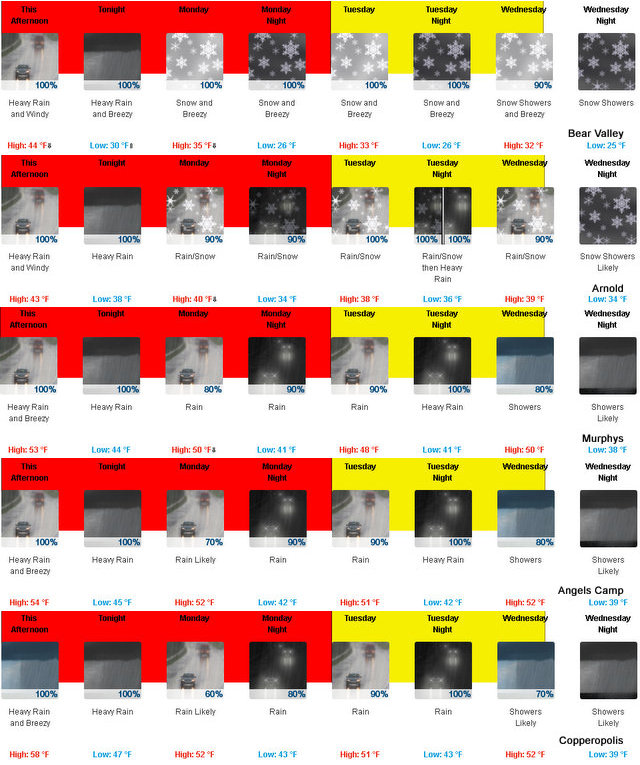
Arnold, CA…The latest from West Slope Northern Sierra Nevada Rest Of Today Heavy rain and isolated thunderstorms. Windy. Not as cool. Highs 37 to 49 higher elevations…46 to 54 lower elevations. Prevailing south winds 20 to 35 mph with gusts to around 60 mph…except south 35 to 50 mph with gusts to around 65 mph over ridges. Tonight At lower elevations, heavy rain showers. At higher elevations, heavy rain showers in the evening, then heavy rain showers and heavy snow showers after midnight. Windy, colder. Lows 25 to 39 higher elevations…36 to 44 lower elevations. No snow accumulation lower elevations…4 to 10 inches higher elevations. Snow level 7500 feet after midnight. Prevailing southwest winds 15 to 30 mph with gusts to around 50 mph…except southwest 25 to 45 mph over ridges.
Monday
At lower elevations, rain in the morning, then rain and snow in the afternoon. At higher elevations, rain and snow in the morning, then snow in the afternoon. Breezy. Highs 27 to 41 higher elevations…38 to 46 lower elevations. No snow accumulation lower elevations…2 to 8 inches higher elevations. Snow level 5500 feet. Prevailing southwest winds 10 to 25 mph with gusts to around 45 mph…except southwest 20 to 35 mph over ridges.
Monday Night
Rain and snow. Windy, colder. Lows 21 to 36 higher elevations…34 to 40 lower elevations. Snow accumulation of 1 to 7 inches lower elevations…except 9 to 15 inches higher elevations. Snow level 4500 feet. Prevailing southwest winds 10 to 30 mph with gusts to around 45 mph. Over ridges, prevailing southwest winds 25 to 35 mph increasing to 25 to 45 mph after midnight.
Tuesday
Snow and heavy rain. Breezy. Highs 27 to 41 higher elevations…38 to 46 lower elevations. No snow accumulation lower elevations…10 to 15 inches higher elevations. Snow level 5000 feet. Prevailing southwest winds 10 to 25 mph with gusts to around 45 mph. Over ridges, prevailing southwest winds 30 to 45 mph with gusts to around 60 mph decreasing to 25 to 35 mph in the afternoon.
Tuesday Night
Heavy snow and heavy rain. Breezy. Heavy snow accumulations possible. Lows 25 to 40.
Wednesday
Rain and snow showers. Breezy. Moderate snow accumulations possible. Highs 30 to 45.
Wednesday Night
Rain and snow showers. Moderate snow accumulations possible. Lows 23 to 38.
Thursday
Snow showers likely. Moderate snow accumulations possible. Highs 29 to 44.
Thursday Night
Cloudy with a chance of rain and snow showers. Lows 21 to 36.
Friday
Mostly cloudy with a chance of rain and snow showers. Not as cool. Highs 33 to 48.
Friday Night And Saturday
Mostly cloudy with a chance of rain and snow. Lows 24 to 39. Highs 35 to 50.
The Latest Forecast Update….Snow Level Starts To Drop Tonight added by admin on
View all posts by admin →