


Markleeville, CA….The lightning caused Washington Fire started 45 miles south of Carson City Nevada. The fire grew to around 8000 acres since initial attack efforts began on Saturday June 19 at around 7:00 p.m. The extreme fire activity being witnessed with the Washington Fire is primarily due to strong erratic winds and severe drought conditions. These two variables also played a role in firefighting efforts for both air and ground support yesterday.
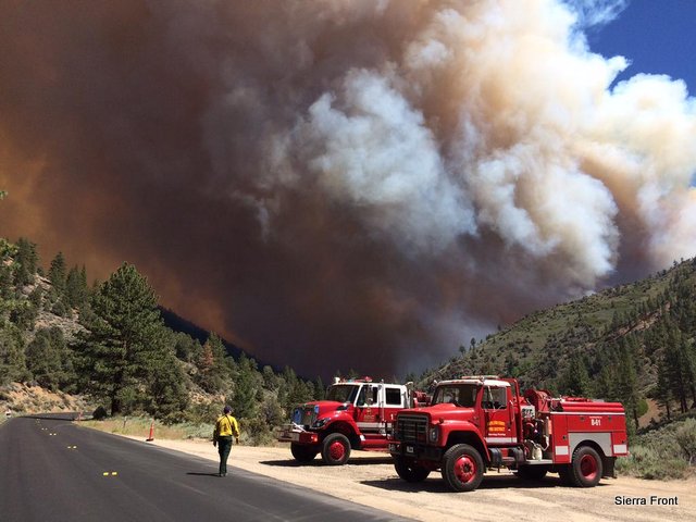
On Sunday June 21, the Type 3 Sierra Front Incident Management Team was assigned to the Washington fire. A transition to a Type 2 incident management team was carried out as of 6:00 a.m. Monday June 22. The interagency Incident Management Team (Great Basin Team 4-Wilcox) took over operation due to the complexities of the incident. Approximately 300 personnel are assigned to the incident with more to arrive today. Fire officials will utilize both air and ground support, in their efforts to combat the blaze. As of 8pm last night the fire was estimated to be approximately 10% contained.
The fire is burning southeast of the mountain community of Markleeville, California. Several campgrounds along Highway 4 to the north end of Markleeville have been evacuated. In addition, Highways 4 and 89 in the Monitor Pass area are closed. As a precaution, Markleeville residences have been advised to prepare for an evacuation if the need arise, however, no mandatory evacuations are in effect for Markleeville at this time.
The weather forecast calls for another day of high winds which will hamper containment efforts. While the winds are expected to subside after today high temperatures are forecasted later in the week along with possible thunder storms that can cause erratic localized winds later in the week.
Basic Information
Current as of 6/21/2015, 10:07:11 PM
Incident Type Wildfire
Cause Lightning/natural
Date of Origin Friday June 19th, 2015 approx. 07:00 PM
Location On CA Highways 4 and 89, 8 to 10 miles south of Markleeville, CA.
Incident Commander Stacey Saucedo
Current Situation
Total Personnel 255
Size 6,500 Acres
Percent of Perimeter Contained 10%
Fuels Involved
Timber (Litter and Understory)
Significant Events
Extreme, Wind Driven Runs
Outlook
Planned Actions
Continue with fire suppression and transition to Type II IMT on Monday. Prioritize air attack early in the day when conditions are optimal.
Remarks
Forecast for gusty winds and low relative humidity of 4 to 5 percent continues. Fire is burning in hazardous and inaccessible terrain and approaching an increasing number of structures and impacting travel corridors.
Current Weather
Weather Concerns
Red Flag conditions, hot and dry gusty winds will persist. High winds are continuing overnight contributing to poor relative humidity recovery. Hundred hour fuel moisture ratings are historically low at 4 to 5.
Washington Fire Grows To Around 8000 Acres added by admin on
View all posts by admin →