


Arnold, CA…The forecast for the West Slope Northern Sierra Nevada is as follows. We also start the week with heat warnings. For those of you new to The Pine Tree we post our weather by elevation starting at Lake Alpine – Bear Valley levels and dropping down by community. These numbers also work well for the Hwy 88 and the Hwy 108 corridors. As the crow flies Hwy 88 and Hwy 109 are only 15-18 miles north and south respectively. So the temps by elevation are usually accurate within a degree or two regardless of which pass you are on.
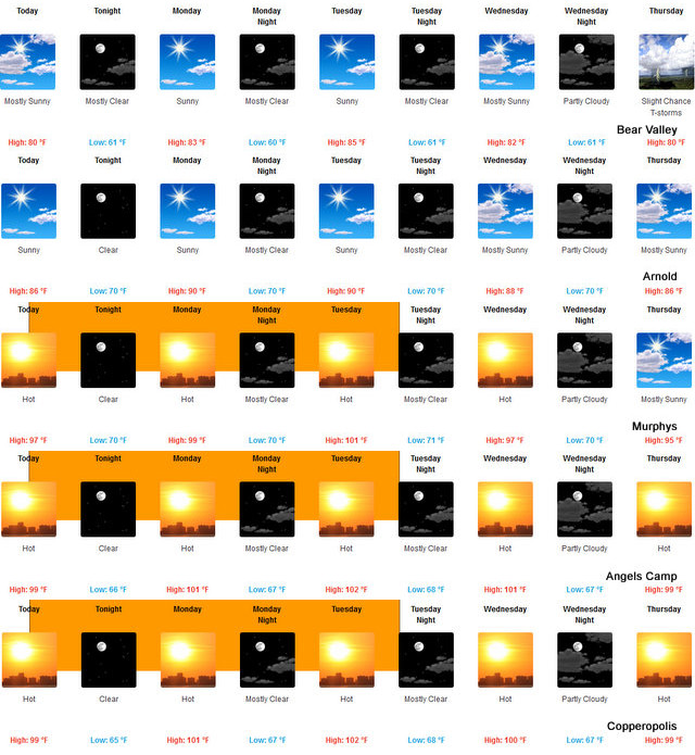
Rest Of Today Mostly sunny. Highs 74 to 89 higher elevations… 87 to 95 lower elevations. Prevailing east winds up to 10 mph shifting to the southwest in the afternoon.
Tonight Clear. Lows 53 to 68 higher elevations…63 to 75 lower elevations. Prevailing southwest winds up to 10 mph shifting to the east after midnight.
Monday Sunny. Highs 76 to 91 higher elevations…87 to 97 lower elevations. Prevailing east winds up to 10 mph shifting to the southwest in the afternoon.
Monday Night Clear. Lows 53 to 68 higher elevations…63 to 75 lower elevations. Prevailing west winds up to 10 mph shifting to the east after midnight.
Tuesday Sunny. Highs 78 to 93 higher elevations…89 to 99 lower elevations. Prevailing east winds up to 10 mph shifting to the southwest in the afternoon.
Tuesday Night Mostly clear. Lows 57 to 72.
Wednesday Mostly sunny. Highs 78 to 93.
Wednesday Night Mostly clear. Lows 57 to 72.
Thursday And Thursday Night Partly cloudy. Highs 76 to 91. Lows 57 to 72.
Friday And Friday Night Mostly clear. A slight chance of rain showers. Highs 75 to 90. Lows 56 to 71.
Saturday Partly cloudy with a slight chance of showers and thunderstorms. Highs 75 to 90.
A Warm Summer Week Ahead with Heat Warnings to Start the Week added by admin on
View all posts by admin →