


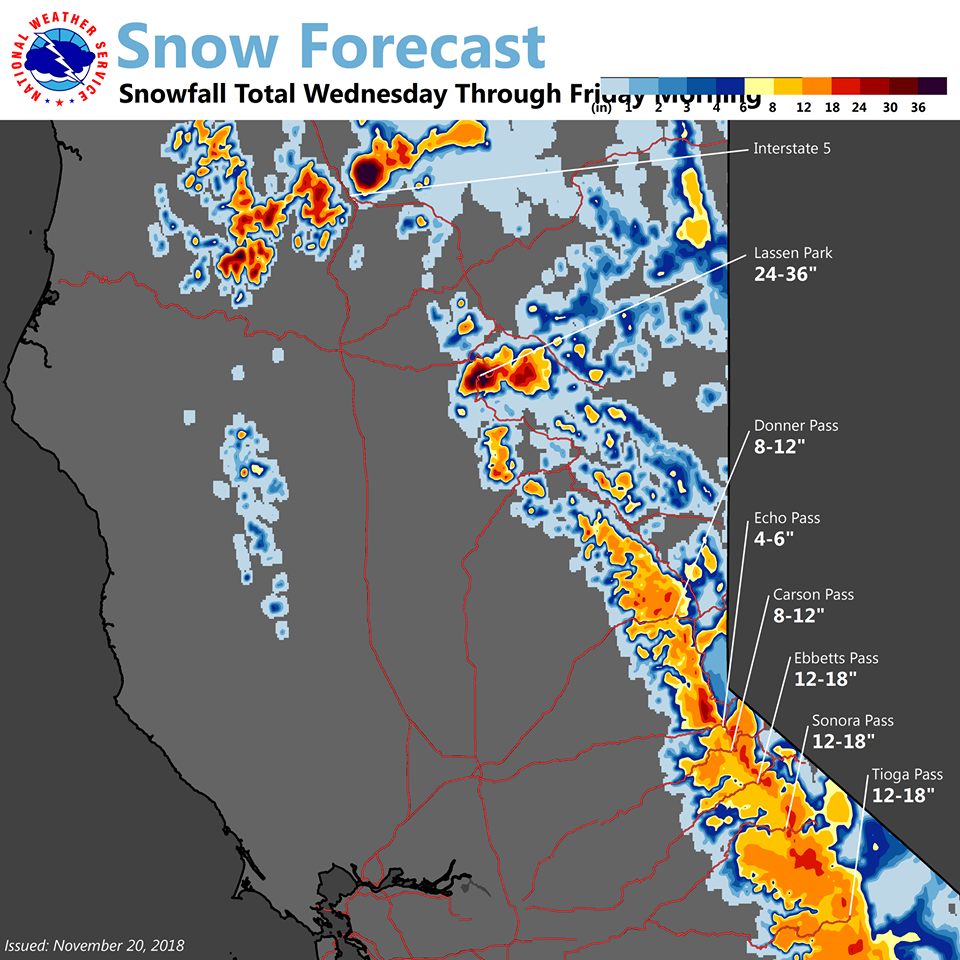
Arnold, CA…The first of a series of storms will bring moderate to heavy snow to the mountains of Western Plumas County and the Northern Sierra Nevada above 6000 feet Wednesday afternoon into late Wednesday night. This will likely disrupt Thanksgiving holiday travel across Sierra passes. After a brief lull, the next storm is expected late Thursday into Friday, with snow levels expected to rise to around 7000 feet by Friday afternoon.
Special Weather Statement
National Weather Service Sacramento CA
418 AM PST Tue Nov 20 2018
CAZ013>019-063-064-066>069-221230-
Shasta Lake Area / Northern Shasta County-
Burney Basin / Eastern Shasta County-Northern Sacramento Valley-
Central Sacramento Valley-Southern Sacramento Valley-
Carquinez Strait and Delta-Northern San Joaquin Valley-
Mountains Southwestern Shasta County to Northern Lake County-
Clear Lake/Southern Lake County-
Northeast Foothills/Sacramento Valley-Motherlode-
Western Plumas County/Lassen Park-
West Slope Northern Sierra Nevada-
Including the cities of Shasta Dam, Burney, Redding, Red Bluff,
Chico, Oroville, Marysville/Yuba City, Sacramento,
Fairfield/Suisun, Stockton, Modesto, Alder Springs, Lakeport,
Paradise, Grass Valley, Jackson, Chester, Quincy, and Blue Canyon
418 AM PST Tue Nov 20 2018
…Major change to Winter Weather forecast for the Holiday
Weekend…
A major change in the weather pattern is coming to NorCal this
week impacting holiday travel. A series of winter like storms
will plow through NorCal bringing rain and mountain snow to the
region. The first system is set to arrive late Tuesday night
pushing through the north state Wednesday and Wednesday night.
Another system will move though late Thursday and Thursday night
with one last system pushing through on Friday.
Snowfall over the Sierra and debris flow over the recent Norcal
Fires are a major concern with these weather systems and hazard
watches have been issued for these impacts.
This change in the weather pattern will bring other impacts as
well. The accumulation of dirt and oils on the roadways will
produce very slick conditions especially early on in this wet
period Tuesday night and Wednesday. The Wednesday evening commute
and Thanksgiving travel period will likely see increased traffic
accidents due to the slick roadways and motorists should use extra
caution. As rainfall accumulates over the holiday weekend,
ponding water will be possible where storm drains have been
clogged by leaves and other debris. In addition to the rainfall,
the weather system passing through norcal late Thursday will bring
gusty south winds. The northern Sacramento valley could see wind
gusts up to 40 or 45 mph with gusts to over 60 mph over the higher
Sierra. Downed tree limbs, blowing objects, and difficult driving
will be a concern during this late Thursday through Friday time
period. Use extra care while traveling this holiday weekend as
many weather related hazards will be present that have not been a
concern for the last several months.
Conditions will begin to improve on Sunday with a return to drier
weather expected early next week.
$$
mcsmith
Winter Storm Watch
URGENT – WINTER WEATHER MESSAGE
National Weather Service Sacramento CA
437 AM PST Tue Nov 20 2018
…MOUNTAIN SNOW WEDNESDAY AFTERNOON THROUGH FRIDAY MORNING FOR
THE SIERRA CASCADE RANGE…
.The first of a series of storms will bring moderate to heavy
snow to the mountains of Western Plumas County and the Northern
Sierra Nevada above 6000 feet Wednesday afternoon into late
Wednesday night. This will likely disrupt Thanksgiving holiday
travel across Sierra passes. After a brief lull, the next storm is
expected late Thursday into Friday, with snow levels expected to
rise to around 7000 feet by Friday afternoon.
CAZ068-069-210000-
/O.EXT.KSTO.WS.A.0012.181121T2000Z-181123T1800Z/
Western Plumas County/Lassen Park-
West Slope Northern Sierra Nevada-
437 AM PST Tue Nov 20 2018
…WINTER STORM WATCH NOW IN EFFECT FROM WEDNESDAY AFTERNOON
THROUGH FRIDAY MORNING ABOVE 6000 FEET…
* WHAT…Heavy snow possible. Travel will be very difficult to
impossible, including during the evening commute on Wednesday.
Damage to trees and power lines is possible. Total snow
accumulations of 4 to 8 inches, with localized amounts up to 12
inches, are possible Wednesday afternoon through Thursday
morning. Total snow accumulations of 4 to 10 inches, with
localized amounts with localized amounts up to 15 inches
possible Thursday afternoon through Friday morning.
* WHERE…Western Plumas County/Lassen Park and West Slope
Northern Sierra Nevada.
* WHEN…From Wednesday afternoon through Friday morning.
* ADDITIONAL DETAILS…Significant reductions in visibility are
possible with wind gusts to 50 mph over higher terrain.
PRECAUTIONARY/PREPAREDNESS ACTIONS…
A Winter Storm Watch means there is potential for significant
snow accumulations that may impact travel. Continue to monitor
the latest forecasts.
$$
Winter Storm Watch Wednesday Afternoon Through Thanksgiving….12 -18 Inches of Snow Over Ebbetts & Sonora Passes added by admin on
View all posts by admin →