


Arnold, CA…Below are the forecasts this week for the West Slope and Mother Lode regions. Detailed forecast for West Slope Northern Sierra Nevada. Today Mostly cloudy. A chance of snow in the morning, then snow likely in the afternoon. Highs 22 to 37 higher elevations… 34 to 44 lower elevations. Snow accumulation up to 2 inches. Prevailing south winds up to 15 mph…except southwest 10 to 25 mph over ridges.
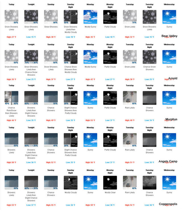
Tonight Mostly cloudy. Snow showers likely in the evening, then a chance of snow showers after midnight. Lows 11 to 26 higher elevations…25 to 31 lower elevations. Snow accumulation up to 2 inches. Prevailing south winds up to 10 mph.
Sunday Mostly cloudy. A chance of snow showers in the morning, then rain and snow showers likely in the afternoon. Highs 24 to 39 higher elevations…39 to 45 lower elevations. Snow accumulation up to 2 inches. Snow level around 4000 feet in the afternoon. Prevailing southeast winds up to 10 mph shifting to the northwest in the afternoon.
Sunday Night Mostly cloudy. A chance of rain and snow showers in the evening. Lows 14 to 29 higher elevations…27 to 33 lower elevations. Little or no snow accumulation lower elevations…up to 2 inches higher elevations. Snow level around 3500 feet. prevailing north winds up to 10 mph shifting to the northeast after midnight.
Monday Partly cloudy in the morning then becoming mostly sunny. Not as cool. Highs 30 to 45 higher elevations…45 to 51 lower elevations. Prevailing northeast winds up to 15 mph.
Monday Night Mostly clear. Lows 18 to 33.
Tuesday Rain and snow likely. Moderate snow accumulations possible. Highs 30 to 45.
Tuesday Night Mostly cloudy with a chance of rain and snow showers. Colder. Lows 15 to 30.
Wednesday Through Friday Mostly clear. Highs 32 to 47. Lows 17 to 32.
Detailed forecast for Motherlode
Today Mostly cloudy. A chance of rain and snow. Highs 40 to 54. No snow accumulation lower elevations…up to 1 inch higher elevations. Snow level 2000 feet in the morning. Prevailing southeast winds up to 15 mph.
Tonight Mostly cloudy. Rain showers likely in the evening, then a chance of rain and snow showers after midnight. Lows 30 to 40. Little or no snow accumulation. Prevailing southeast winds up to 10 mph.
Sunday Mostly cloudy. A slight chance of rain and snow showers in the morning, then a chance of rain showers in the afternoon. Highs 43 to 57. Light winds.
Sunday Night Mostly cloudy with a slight chance of rain showers in the evening, then partly cloudy after midnight. Lows 31 to 39. Light winds.
Monday Mostly sunny. Not as cool. Highs 49 to 61. Prevailing east winds up to 10 mph in the morning becoming light.
Monday Night Mostly clear. Lows 33 to 41.
Tuesday Rain likely. Highs 43 to 55.
Tuesday Night Mostly cloudy with a chance of rain showers. Lows 29 to 39.
Wednesday And Wednesday Night Mostly clear. Highs 45 to 57. Lows 29 to 39.
Thursday Sunny. Highs 47 to 59.
Thursday Night And Friday Mostly clear. Lows 33 to 41. Highs 49 to 61.
A Bit of Sun in the Forecast, No Really, The Sun Will Make an Appearance or Two added by admin on
View all posts by admin →