


Arnold, CA…Thankfully we have precipitation in liquid & flakes heading our way over Thanksgiving. The detailed forecast for the West Slope Northern Sierra Nevada, Mother Lode & Winter Storm Warning is below. Today Sunny. Not as cool. Highs 41 to 56 higher elevations… 54 to 64 lower elevations. Prevailing east winds up to 10 mph.
Tonight Clear. Lows 22 to 37 higher elevations…31 to 46 lower elevations. Prevailing east winds up to 10 mph.
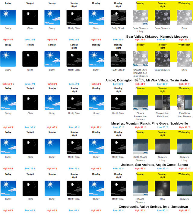
Sunday Sunny. Not as cool. Highs 46 to 61 higher elevations… 56 to 66 lower elevations. Prevailing east winds up to 10 mph in the morning becoming light. Sunday Night Mostly clear. Lows 23 to 38 higher elevations… 32 to 46 lower elevations. Light winds becoming south up to 10 mph after midnight.
Monday Mostly sunny. Highs 36 to 51 higher elevations…48 to 60 lower elevations. Prevailing southwest winds up to 10 mph shifting to the northwest in the afternoon. Monday Night Mostly clear. Colder. Lows 20 to 35.
Tuesday Mostly cloudy with a chance of snow showers. Highs 30 to 45. Tuesday Night Through Thanksgiving Day Snow showers. Heavy snow accumulations possible. Lows 18 to 33. Highs 24 to 39. Thursday Night Snow showers likely. Moderate snow accumulations possible. Lows 17 to 32. Friday Mostly cloudy with a chance of snow showers. Highs 26 to 41.
The Detailed forecast for the Mother lode. Today Sunny. Highs 58 to 68. Light winds. Tonight Clear. Lows 34 to 48. Light winds becoming east up to 10 mph after midnight.
Sunday Sunny. Highs 60 to 68. Light winds. Sunday Night Clear. Lows 34 to 46. Light winds. Monday Mostly sunny. Highs 55 to 65. Light winds becoming northwest up to 10 mph in the afternoon. Monday Night Mostly clear. Colder. Lows 30 to 42.
Tuesday Mostly cloudy with a chance of rain and snow showers. Highs 44 to 54. Tuesday Night Rain and snow showers likely. Moderate snow accumulations possible. Lows 29 to 41.
Wednesday Rain showers, snow and a slight chance of thunderstorms. Moderate snow accumulations possible. Highs 36 to 48. Wednesday Night Rain showers, snow showers and a slight chance of thunderstorms. Moderate snow accumulations possible. Lows 28 to 40.
Thanksgiving Day And Thursday Night Rain showers, snow showers likely and a slight chance of thunderstorms. Light snow accumulations possible. Highs 38 to 50. Lows 28 to 40. Friday Mostly cloudy with a chance of rain and snow showers. Highs 39 to 51.
Winter Storm Watch
URGENT – WINTER WEATHER MESSAGE
National Weather Service Sacramento CA
253 AM PST Sat Nov 23 2019
…A significant winter storm likely to impact the region during
peak Thanksgiving holiday travel…
.A strong upper low currently west of Alaska is expected to reach
the northern California coast by Tuesday. Heavy snowfall is
likely by Tuesday evening and continues through the overnight
hours and into Wednesday. Snow combined with breezy conditions
may significantly reduce visibilities. Accumulating snow is
likely down into the upper foothills, potentially lower. Hazardous
mountain travel with significant delays is possible. Snow showers
will continue through Thanksgiving Day, possibly into Friday.
CAZ014-066>069-240000-
/O.EXT.KSTO.WS.A.0014.191126T1800Z-191129T1200Z/
Burney Basin / Eastern Shasta County-
Northeast Foothills/Sacramento Valley-Motherlode-
Western Plumas County/Lassen Park-
West Slope Northern Sierra Nevada-
Including the cities of Burney and Grass Valley
253 AM PST Sat Nov 23 2019
…WINTER STORM WATCH NOW IN EFFECT FROM TUESDAY MORNING THROUGH
LATE THURSDAY NIGHT ABOVE 2500 FEET…
* WHAT…Heavy snow possible. Plan on difficult travel
conditions, including during the evening commute on Tuesday.
Several feet of snow will be possible above 4,000 feet with
accumulations expected down to the upper foothills.
* WHERE…Burney Basin / Eastern Shasta County, Northeast
Foothills/Sacramento Valley, Motherlode, Western Plumas
County/Lassen Park and West Slope Northern Sierra Nevada.
* WHEN…From Tuesday morning through late Thursday night.
* ADDITIONAL DETAILS…Significant reductions in visibility are
possible. Downed trees and power outages possible.
PRECAUTIONARY/PREPAREDNESS ACTIONS…
A Winter Storm Watch means there is potential for significant
snow, sleet or ice accumulations that may impact travel. Continue
to monitor the latest forecasts.
$$
Thanksgiving Week Weather, Winter Storm Watch & More for The Western Slope & Mother Lode added by admin on
View all posts by admin →