


Arnold, CA…Mother Nature is making sure the fire season is doused, stirred & doused some more. Now we can look forward to a great holiday season. Winter storm watches && forecasts for the West Slope & Mother Lode. Detailed forecast for West Slope Northern Sierra Nevada. Rest Of Today Heavy rain at lower elevations…and heavy rain and snow at higher elevations. Not as cool. Highs 30 to 42 higher elevations…41 to 47 lower elevations. No new snow accumulation lower elevations…except new snow accumulation of 1 to 7 inches higher elevations. Snow level 7000 feet. Prevailing south winds 5 to 15 mph with gusts to around 30 mph…except south 20 to 30 mph over ridges.
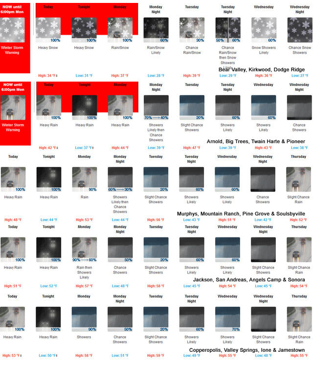
Tonight Heavy rain at lower elevations…and heavy rain and snow at higher elevations. Lows 26 to 38 higher elevations… 37 to 45 lower elevations. No snow accumulation lower elevations…8 to 14 inches higher elevations. Snow level 7000 feet. Prevailing south winds 5 to 15 mph with gusts to around 30 mph…except south 15 to 30 mph over ridges.
Monday At lower elevations, rain in the morning, then rain showers in the afternoon. At higher elevations, rain and snow in the morning, then rain and snow showers in the afternoon. Highs 31 to 46 higher elevations…45 to 53 lower elevations. No snow accumulation lower elevations…2 to 8 inches higher elevations. Snow level 7500 feet. Prevailing southeast winds up to 15 mph.
Monday Night Mostly cloudy. Rain and snow showers likely in the evening, then a chance of rain and snow showers after midnight. Lows 24 to 39 higher elevations…36 to 46 lower elevations. No snow accumulation lower elevations…up to 3 inches higher elevations. Snow level above 8000 feet. Prevailing southeast winds up to 10 mph.
Tuesday Mostly cloudy with a slight chance of rain and snow showers. Highs 32 to 47 higher elevations…46 to 56 lower elevations. No snow accumulation lower elevations…up to 1 inch higher elevations. Snow level above 8000 feet. Prevailing southeast winds up to 10 mph.
Tuesday Night Mostly cloudy with a chance of rain and snow showers. Lows 27 to 42.
Wednesday Cloudy with a chance of rain and snow showers. Highs 34 to 49.
Wednesday Night Mostly cloudy with a chance of rain and snow showers. Lows 26 to 41.
Thursday Mostly cloudy with a slight chance of rain and snow. Highs 36 to 51.
Thursday Night Mostly cloudy with a chance of rain and snow. Lows 27 to 42.
Friday Mostly cloudy with rain and snow likely. Breezy. Heavy snow accumulations possible. Highs 34 to 49.
Friday Night Heavy rain and snow likely. Breezy, colder. Heavy snow accumulations possible. Lows 24 to 39.
Saturday Rain and snow likely. Highs 29 to 44.
Detailed forecast for Mother lode
Rest Of Today Heavy rain. Highs 45 to 54. Prevailing southeast winds 5 to 15 mph.
Tonight Heavy rain. Lows 40 to 52. Prevailing southeast winds 5 to 15 mph.
Monday Rain showers. Highs 50 to 60. Prevailing southeast winds 5 to 15 mph.
Monday Night Mostly cloudy. Rain showers likely in the evening, then a chance of rain showers after midnight. Lows 40 to 52. Prevailing east winds up to 10 mph.
Tuesday Mostly cloudy with a slight chance of rain showers. Highs 52 to 62. Light winds.
Tuesday Night Mostly cloudy with a chance of rain showers. Lows 39 to 51.
Wednesday Cloudy with a chance of rain showers. Highs 48 to 58.
Wednesday Night Mostly cloudy with a slight chance of rain showers. Lows 39 to 49.
Thursday Mostly cloudy with a slight chance of rain. Highs 49 to 59.
Thursday Night Mostly cloudy with a chance of rain. Lows 39 to 51.
Friday And Friday Night Rain likely. Highs 47 to 59. Lows 36 to 51.
Saturday Rain likely. Highs 42 to 54.
Winter Storm Warning
URGENT – WINTER WEATHER MESSAGE
National Weather Service Sacramento CA
1014 AM PST Sun Dec 1 2019
…Winter travel impacts through Monday…
.A significant winter storm will continue to impact the region
through Monday. Snow levels will continue to gradually rise
throughout the day and into Monday, and are expected to be near
Sierra Nevada pass levels tonight.
Travelers should prepare for wintry weather. Snow will cause
travel delays through today. Travel conditions could improve
tonight and Monday as snow levels rise to near the mountain
passes.
CAZ069-020300-
/O.CON.KSTO.WS.W.0018.000000T0000Z-191203T0200Z/
West Slope Northern Sierra Nevada-
1014 AM PST Sun Dec 1 2019
…WINTER STORM WARNING REMAINS IN EFFECT UNTIL 6 PM PST MONDAY
ABOVE 6500 FEET…
* WHAT…Heavy snow occurring. Travel will be very difficult to
impossible. Additional snow accumulations of 21 to 25 inches,
with localized amounts up to 48 inches, are expected.
* WHERE…West Slope Northern Sierra Nevada.
* WHEN…Until 6 PM Monday.
* ADDITIONAL DETAILS…Be prepared for significant reductions in
visibility at times.
PRECAUTIONARY/PREPAREDNESS ACTIONS…
A Winter Storm Warning for snow means there will be snow covered
roads and limited visibilities. Travel is not recommended while
the warning is in effect. If you must travel, keep an extra
flashlight, food and water in your vehicle in case of an
emergency.The latest road conditions for the state you are
calling from can be obtained by calling 5 1 1.
$$
The Deluge Continues This Week With A Wet & Snowy Start to Christmas Season added by admin on
View all posts by admin →