


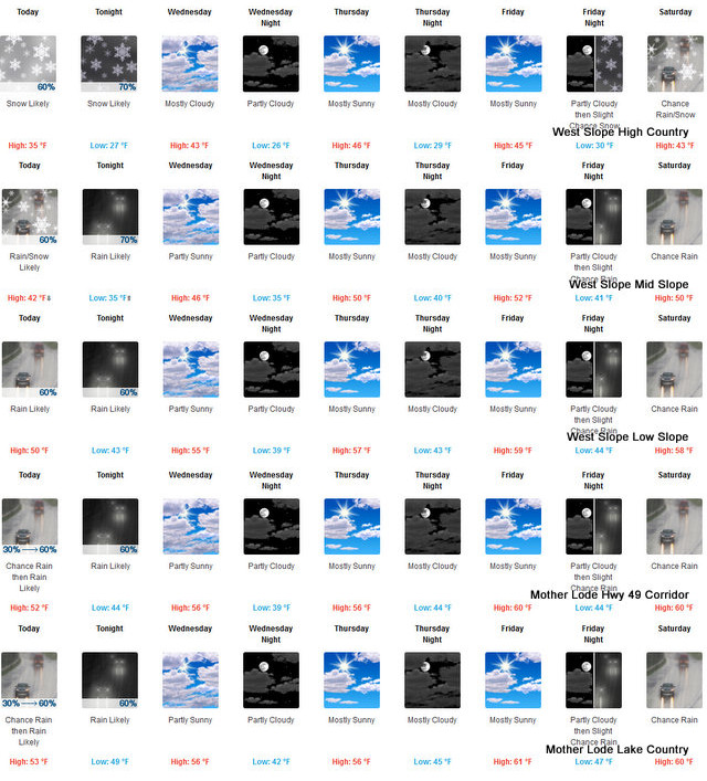
Arnold, CA…The Detailed forecast for the West Slope Northern Sierra Nevada from the National Weather Service Sacramento’s Office is below. Today Mostly cloudy. A chance of rain and snow in the morning, then rain and snow in the afternoon. Highs 28 to 43 higher elevations…39 to 49 lower elevations. No snow accumulation lower elevations…2 to 4 inches higher elevations. Snow level 5500 feet. Prevailing south winds 5 to 15 mph with gusts to around 35 mph…except southwest 15 to 35 mph over ridges.
Tonight
Mostly cloudy. At lower elevations, rain in the evening, then a chance of rain after midnight. At higher elevations, rain and snow likely in the evening, then a chance of rain and snow after midnight. Lows 22 to 37 higher elevations… 34 to 42 lower elevations. No snow accumulation lower elevations…up to 2 inches higher elevations. Snow level 6000 feet. Prevailing south winds up to 15 mph with gusts to around 35 mph…except southwest 15 to 35 mph over ridges.
Wednesday
Mostly cloudy. Not as cool. Highs 35 to 50 higher elevations…46 to 54 lower elevations. Prevailing south winds up to 10 mph.
Wednesday Night
Mostly cloudy in the evening then becoming mostly clear. Lows 21 to 36 higher elevations…33 to 41 lower elevations. Prevailing east winds up to 10 mph.
Thursday
Mostly sunny in the morning then becoming partly cloudy. Not as cool. Highs 38 to 53 higher elevations…51 to 59 lower elevations. Prevailing east winds up to 10 mph in the morning becoming light.
Thursday Night
Mostly cloudy. Lows 27 to 42.
Friday
Partly cloudy. Highs 42 to 57.
Friday Night
Partly cloudy. Lows 27 to 42.
Saturday And Saturday Night
Mostly cloudy with a chance of rain and snow. Highs 39 to 54. Lows 29 to 44.
Sunday And Sunday Night
Rain and snow likely. Moderate snow accumulations possible. Highs 36 to 51. Lows 28 to 43.
Monday
Mostly cloudy with a chance of rain and snow showers. Highs 35 to 50.
Snow Possible Above 5,500 Feet Today & 6,000 Feet Tonight. Mostly Cloudy Tomorrow added by admin on
View all posts by admin →