


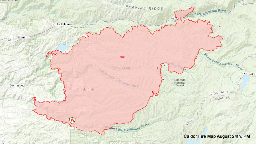
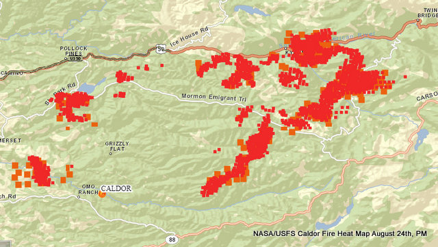
Grizzly Flats, CA…The fire was active in the early portion of the day due to the inversion layer lifting rapidly. The Northeast side of the fire saw the most movement towards Hwy 50 and Twin Bridges aided by up canyon winds and spotting distances up to a half mile away. In areas that were in alignment with winds, passive crown fire runs were seen. Throughout the incident spot fires continued to be found with the large spot fire north of Hwy 50 growing moderately due to rollout. With the moderate break in weather, crews continued to improve and strengthen containment lines.
To better provide public and firefighter safety due to extreme fire conditions throughout Northern California, and strained firefighter resources throughout the Country, the USDA Forest Service Pacific Southwest Region is announcing a temporary closure of nine National Forests. This closure will be effective on August 22, 2021, at 11:59 p.m. through September 6, 2021, at 11:59 p.m. The closure order can be found at https://tinyurl.com/USFSClosure.
AMADOR COUNTY -WARNINGS
• Shenandoah Road at the Amador County line west through the River Pines community, continuing west on Shenandoah Road to Ostrom Road.
• South on Ostrom Road to Jibboom Street, West on Jibboom Street to Fiddletown Road.
• East on Fiddletown Road to Hale Road. South on Hale Road to Shake Ridge Road.
• East on Shake Ridge Road to Charleston Road.
• South on Charleston Road to the intersection of Charleston Road and Rams Horn Grade.
• Due east to Highway 88 at Tiger Creek Road.
• Tiger Creek Road east to Salt Springs Reservoir Road.
• East on Salt Springs Reservoir Road to the east end of the Salt Springs Reservoir.
• Due north from the east end of Salt Springs Reservoir to Highway 88.
• South of the El Dorado-Amador County line with a western border of Highway 88 due south to the east end of Salt Springs Reservoir.
• Southern border of the Calaveras County line.
• Eastern border of the Alpine County line.
EL DORADO COUNTY – ORDERS
• Grizzly Flat: The areas on Grizzly Flats Road east of Kendra Way into Grizzly
• Flats Proper. The areas of Diamond Railroad Grade, Old School House, Sweeney Road, Caldor Road, and steely Ridge.
• Grizzly Flats Road east of four corners in somerset into Grizzly Flats Proper.
• The areas of Myers Lane, Varmet Ridge Road, Rodwell Canyon Road, Snowbird Lane, and Mehwald Lane.
• East of Sly Park Road between Highway 50 and Mormon Emigrant Trail to Ice House Road. This includes the communities of Pacific House and Fresh Pond.
• North of Highway 50, east of Forebay Road to Ice House Road.
• Intersection of Perry Creek and Hawk Haven, the East side of Fairplay Road from Perry Creek South to Cedarville Road. This includes Slug Gulch, Omo Ranch, and all roads off of Slug Gulch and Omo Ranch.
• All roads off of Omo Ranch from Cedarville Road to Hwy 88.
• The area between Highway 88 and Mormon Emigrant Trail
• South of Highway 50 from Snows Road to Ice House Road.
• Between Highway 50 and Slab Creek from Snows Road to Ice House Road.
• South of Highway 50 from Ice House Road to Silver Fork Road. This includes the community of Kyburz.
• North of Highway 50 from Ice House Road to Silver Fork Road to include Ice House Reservoir, Union Valley Reservoir, and Loon Lake.
• Silver Fork Road in Kyburz east to Twin Bridges.
• North and south in a line extending from Twin Bridges to the Placer County line and south to the Amador County line. • Areas south of Farnham Ridge Road and east of Bridgeport School Road to the Amador County line.
EL DORADO COUNTY – WARNINGS:
• North of Slab Creek to Wentworth Springs Road between Sand Mountain and Loon Lake.
• Mosquito Road from the bridge North to include the Community of Swansboro.
• North of Highway 50 to Slab Creek between Smith Flat and Snows Road.
• South of Highway 50 to Pleasant Valley between Smith Flat and Snows Road, and North of Pleasant Valley between Holm and Newtown.
• South of Pleasant Valley between Bucks Bar Road and Newtown Road, East of Bucks Bar Road to Mt Aukum Road.
• Southwest of Bucks Bar Road to Ladies Valley Road including the community of Outingdale, Ant Hill Road, Perry Creek Road and Sand Ridge between Ladies Valley Road and Bucks Bar Road.
• East of Mt Aukum Road (E16) from Bucks Bar Road to Omo Ranch Road. North of Omo Ranch Road to the intersection of Omo Ranch Road and Fairplay Road.
• South of Omo Ranch to the El Dorado County Line between Mt Aukum Road (E16) and Fairplay Road to include Coyoteville Road, Cedar Creek and all tributary roads.
• From the evacuation order line in Twin Bridges east to the Echo Summit and from Highway 50 south to the Amador and Alpine County lines and north to the Placer County line.
• Dry Lakes Section: This section is north of Wentworth Springs Road up to the Placer County line and the remaining section of El Dorado County south of Placer County to Loon Lake.
EL DORADO COUNTY – ROAD CLOSURES
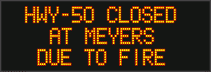
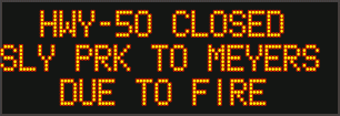
Highway 50 will be closed in both directions from the Sly Park Road exit to Twin Bridges.
Highway 50 will be open between Meyers and Twin Bridges for local residents only who reside between Meyers and Twin Bridges. These residents will be subject to providing identification and proof of residency.
No traffic will be allowed west past Twin Bridges.
Shelter Green Valley Community Church 3500 Missouri Flat Road Placerville, CA
Shelter- FULL Cameron Park CSD 2502 Country Club Drive Cameron Park, CA
Temporary Evacuation Point Amador County Fairgrounds 18621 Sherwood Street Plymouth, CA
Shelter Evelynn Bishop Hall 701 Hwy 124 Ione, CA 855-755-7711
Shelter Rolling Hills Church 800 White Rock Road El Dorado Hills, CA
Shelter Douglas County Community Center 1329 Waterloo Lane Gardnerville, NV
Animal Evac. Center(s): El Dorado
County Animal Services (small animals) 6435 Capitol Ave. Diamond Springs, CA For animal evacuation questions or assistance call (530) 621-5795
Saureel Vineyards (large animals)- FULL 1140 Cold Springs Road Placerville, CA (530) 621-5795
Amador County Fairgrounds (large animal)- for Amador County residents only 18621 Sherwood Street Plymouth, CA
ASSIGNED RESOURCES
Engines: 239 Water Tenders: 26 Helicopters: 18 Hand Crews: 71 Dozers: 51 Other: 6 Total Personnel: 2531 Air Tankers: Numerous firefighting air tankers from throughout the State are flying fire suppression missions as conditions allow.
Cooperating Agencies: El Dorado County Sheriff’s Office, Sierra Pacific Industries, Pioneer FD, PG&E, CHP, El Dorado Irrigation District, El Dorado County, Grizzly Flats Community Service District, SMUD, Amador County Sheriff’s Office, AT&T, Georgetown FD, CALTRANS, Indian Diggins School District, El Dorado County FD, Grizzly Flats Water District, Volcano Telephone, Placerville FD, El Dorado County DOT, Mosquito FD, Garden Valley FD, Cal OES Fire, El Dorado County EMSA, El Dorado County Office of Education, Marshall Medical Center, Shingle Springs Band of Miwok Indians FD, State Water Resources Control Board, KAMPS, El Dorado County Department of Agriculture, Barton Health, CAL EPA, Lake Valley Fire District, and Verizon.
Caldor Fire Now 122,980 Acres, 11% Contained, 637 Structures Destroyed & Inching Towards Lake Tahoe added by admin on
View all posts by admin →