

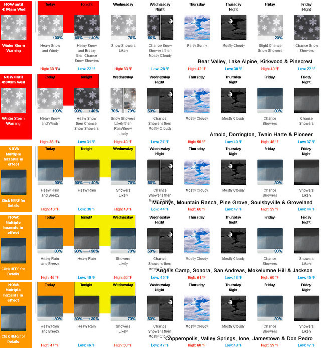
Arnold, CA…Detailed NWS forecast for West Slope Northern Sierra Nevada. Today, At lower elevations, heavy rain showers and a slight chance of thunderstorms early in the morning, then heavy rain showers, heavy snow showers and a slight chance of thunderstorms in the late morning and afternoon. At higher elevations, heavy snow showers and heavy rain showers early in the morning, then heavy snow showers and a slight chance of thunderstorms in the late morning and afternoon. Windy. Highs 26 to 41 higher elevations…37 to 47 lower elevations. Snow accumulation up to 2 inches lower elevations…except 21 to 27 inches higher elevations. Snow level 5000 feet. Prevailing south winds 15 to 35 mph with gusts to around 55 mph.

Tonight
Cloudy. Heavy snow showers, rain showers and a slight chance of thunderstorms in the evening, then a chance of heavy snow showers with possible showers and thunderstorms likely after midnight. Breezy, colder. Lows 17 to 32 higher elevations…30 to 38 lower elevations. Snow accumulation 2 to 4 inches lower elevations…except 7 to 12 inches higher elevations. Snow level 4500 feet. Prevailing south winds 10 to 25 mph with gusts to around 45 mph.
Wednesday
Mostly cloudy. A chance of rain and snow showers in the morning, then rain and snow showers likely in the afternoon. Not as cool. Highs 29 to 43 higher elevations…40 to 48 lower elevations. Snow accumulation up to 1 inch lower elevations… Except 1 to 4 inches higher elevations. Snow level 4000 feet increasing to 5000 feet in the afternoon. Prevailing south winds 5 to 15 mph with gusts to around 30 mph.
Wednesday Night
Mostly cloudy. Rain and snow showers likely in the evening, then a chance of rain and snow showers after midnight. Lows 24 to 38 higher elevations…36 to 44 lower elevations. No snow accumulation lower elevations…up to 3 inches higher elevations. Snow level 7000 feet. Prevailing south winds 5 to 15 mph with gusts to around 30 mph.
Thursday
Mostly cloudy. A slight chance of rain showers in the morning. Not as cool. Highs 36 to 51 higher elevations…49 to 59 lower elevations. Snow level above 8000 feet. Prevailing south winds 5 to 15 mph.
Thursday Night
Mostly cloudy. Lows 29 to 44.
Friday
Mostly cloudy with a chance of rain and snow showers. Highs 39 to 54.
Friday Night
Mostly cloudy with a chance of rain and snow showers. Lows 27 to 42.
Saturday
Rain showers and heavy snow showers likely. Moderate snow accumulations possible. Highs 32 to 47.
Saturday Night
Mostly cloudy with rain showers likely and a chance of heavy snow showers. Colder. Moderate snow accumulations possible. Lows 24 to 39.
Sunday
Mostly cloudy with a chance of rain and snow showers. Highs 30 to 45.
Sunday Night And Martin Luther King Jr Day
Heavy rain and snow showers likely. Heavy snow accumulations possible. Lows 23 to 38. Highs 28 to 43.
Detailed forecast for
Motherlode
Today
Rain showers and a slight chance of thunderstorms. Windy. Some thunderstorms may produce heavy rainfall. Highs 44 to 54. Prevailing south winds 15 to 30 mph. Gusts up to 45 mph in the morning.
Tonight
Cloudy. Rain showers and a slight chance of thunderstorms in the evening, then a chance of rain showers and a slight chance of thunderstorms after midnight. Some thunderstorms may produce heavy rainfall. Lows 35 to 45. Prevailing south winds 5 to 15 mph.
Wednesday
Mostly cloudy. A chance of rain showers in the morning, then rain showers in the afternoon. Highs 45 to 53. Prevailing southeast winds 5 to 15 mph with gusts to around 30 mph.
Wednesday Night
Mostly cloudy. Rain showers likely in the evening, then a chance of rain showers after midnight. Lows 40 to 48. Prevailing southeast winds 5 to 15 mph with gusts to around 30 mph.
Thursday
Mostly cloudy. A slight chance of rain showers in the morning. Not as cool. Highs 56 to 64. Prevailing southeast winds up to 10 mph.
Thursday Night
Mostly cloudy. Lows 44 to 50.
Friday
Mostly cloudy with a chance of rain showers. Highs 54 to 62.
Friday Night
Mostly cloudy with a chance of rain showers. Lows 40 to 48.
Saturday And Saturday Night
Rain showers. Highs 47 to 57. Lows 38 to 48.
Sunday
Mostly cloudy with a chance of rain showers. Highs 44 to 54.
Sunday Night And Martin Luther King Jr Day
Rain showers likely. Lows 37 to 45. Highs 42 to 52.
Mother Nature May Let Us See The Sun on Thursday During Her Groundwater Level Recovery Program added by admin on
View all posts by admin →