

Arnold, CA…Dear Arnold Rim Trail Cyclists, Equestrians, Hikers, and Runners, • Last Volunteer Trail Work Morning of 2023, Sat, Oct 21st. See details below. • Last Guided Cougar Rock Sunset Hike of 2023, Friday, Oct 27th. See details below. • New version of ART map now available for smartphone. Download now! We have added ten miles of new trail to the Arnold Rim Trail system. See details below

Warm regards,
Arnold Rim Trail Association
Please direct questions to: info@arnoldrimtrail.org

2023 Volunteer Trail Building Mornings: May 20, June 17, July 8, Aug 19, Sept 16, and Oct 21.
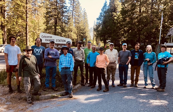
All trail building mornings meet at the Forest Service Ranger Station in Hathaway Pines at 8:30 am. After a brief safety orientation by Chief Trail Officer Greg, we will car pool to the section of trail we will work that day. Since it often gets warm as the morning progresses, please bring layers, gloves, hat, sunscreen, bug repellant, and water. Please wear long pants as we occasionally encounter a bit of poison oak. If you have a favorite garden tool like loppers, bring those, but we will have tools for everyone. Folks from eight to eighty-eight are invited; children should have adult supervision. We wrap up by 11:30am, sometimes a little earlier. If you have another obligation that day, feel free to depart sooner as needed.
Trail building mornings are the third Saturday of each month from May through October, with the exception of July which will take place on the 2nd Saturday, on July 8th.
2023 Guided Sunset Hikes to Cougar Rock:
Friday May 5th, Sunday May 28, Sunday July 2, Saturday August 26, Friday September 29, Friday Oct 27
Watch the sunset from the top of Cougar Rock on this intermediate hike led by members of the Arnold Rim Trail Association. Distance is about 4 miles total, with 730 feet of elevation gain. If you haven’t done one of these hikes, you owe it to yourself to join the fun. They are scheduled on weekends near or on the day of the full moon each month, and they are special!
IMPORTANT NOTES:
1) This is an intermediate level four mile hike with 730 feet of elevation gain, the equivalent of a seventy-three story building. We take plenty of time with frequent stops. That said, it is not a hike for beginners. Please assess your level of conditioning. If you would struggle with a seventy-three story building, even with stops, please take a few weeks of regular training to make yourself ready. It’ll be worth the investment!
2) If this is your first time driving to the parking area, please do not approach on Valley View Drive from Avery Sheep Ranch Road. Instead approach by starting in Arnold and turning off Highway 4 onto Lakemont Drive, followed by a quick left turn onto Valley View Drive. More travel instructions are below.
3) Bring a headlamp or flashlight, bug repellent, a snack, water, and layers.
No sign-up needed, hike proceeds even if cloudy, but rain cancels. (And if the weather has been wet, please see caution below about road condition on the half mile dirt portion of Valley View Drive.) Again, please bring layers, snack, water, bug repellant and flashlight as return hike is in the dark.
Please arrive at the parking lot at least fifteen minutes before departure time for introductions and a brief orientation by the hike leader, as departure times are prompt:
May 28th, Sunday, arrive by 6:15pm, hike departs promptly at 6:30pm
July 2nd, Sunday, arrive by 6:30pm, hike departs promptly at 6:45pm
Aug 26th, Saturday, arrive by 5:40pm, hike departs promptly at 5:55pm
Sept 29th, Friday, arrive by 4:45pm, hike departs promptly at 5:00pm
Oct 27th, Friday, arrive by 4:05pm, hike departs promptly at 4:20pm
(Return to vehicles about two and a half hours after departing.)
The trailhead is at the intersection of Valley View Drive and Forest Rte 5N95Y.
Here’s a link to Google Maps of this intersection.
Drive 1.50 miles on Valley View Drive from the intersection of Lakemont Drive and Valley View Drive in Arnold. The first mile of Valley View Drive is paved, and the last 0.45 miles is dirt. There is no sign at the intersection of Valley View Drive with Forest Rte 5N95Y, but you will see a parking area on the right with a picnic table at that location. Here’s a link to Google Maps that shows the drive from the intersection of Lakemont Drive and Valley View Drive in Arnold to the intersection of Valley View Drive and Forest Rte 5N95Y.
Caution about wet weather driving: Please note that in wet weather, the half mile dirt portion of Valley View Drive can be very slippery. Two wheel drive vehicles have difficulty driving back up the hill after the hike. All-wheel drive vehicles highly recommended in wet-weather.
The GPS coordinates of the trailhead:
38.21938, -120.37873
Questions? Email info@arnoldrimtrail.org. Pictures of the sunset hikes are often posted to the ARTA facebook page. Navigate to “Arnold Rim Trail Association” in your Facebook search field.
2022 update of the ART map now available for smartphones!
Our last map was issued in 2014. This new 2022 update adds ten miles of new trail to the Arnold Rim Trail system and includes two new loop hikes, the Cowboy Loop Trail and the Sunset Loop Trail.
The Arnold Rim Trail Association is honored to partner with Avenza Maps to bring the Arnold Rim Trail map to your mobile phone. Once you have downloaded the map to your phone, you will not need cell service to know exactly where you are on the trail. No charge for either the Avenza Maps app or the ART map.
Use your phone’s camera to scan the code below to download the app & map.
Be sure to click the box to download the new version please.

or tap here to download the map.
Arnold Rim Trail Update…Trail Work, Cougar Rock Sunset Hike & New Maps added by admin on
View all posts by admin →