


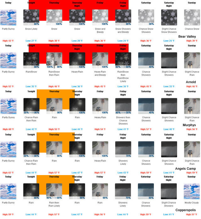
Arnold, CA…A new storm system will roll through the next few days. Along the West Slope Northern Sierra Nevada
it should feel like a cake walk after the last systems. At higher elevations it should put a fresh coat of white on everything for the upcoming weekend. Today Partly cloudy in the morning then becoming mostly cloudy. Highs 37 to 51 higher elevations…48 to 58 lower elevations. Prevailing southeast winds 5 to 15 mph. Tonight Mostly cloudy. At lower elevations, a slight chance of rain in the evening, then a chance of rain and snow after midnight. At higher elevations, a slight chance of rain and snow in the evening, then a chance of rain and snow after midnight. Lows 22 to 37 higher elevations…34 to 40 lower elevations. No snow accumulation lower elevations…up to 2 inches higher elevations. Snow level 5500 feet. Prevailing southeast winds 5 to 15 mph with gusts to around 35 mph…except south 15 to 30 mph over ridges.
We Always Have The Latest Weather & Chain Control Information On Our Weather Page.
Thursday
At lower elevations, rain and snow in the morning, then rain in the afternoon. At higher elevations, snow in the morning, then rain and snow in the afternoon. Highs 33 to 45 higher elevations…41 to 51 lower elevations. No snow accumulation lower elevations…2 to 7 inches higher elevations. Snow level 5000 feet increasing to 6500 feet in the afternoon. Prevailing south winds 5 to 15 mph with gusts to around 30 mph… Except south 15 to 30 mph over ridges.
Thursday Night
Rain and snow likely in the evening, then heavy rain and snow after midnight. Lows 24 to 39 higher elevations… 36 to 42 lower elevations. No snow accumulation lower elevations…3 to 5 inches higher elevations. Snow level 6500 feet. Prevailing south winds 10 to 20 mph with gusts to around 35 mph…except south 15 to 30 mph over ridges.
Friday
Heavy rain and snow in the morning, then heavy rain and snow showers in the afternoon. Breezy. Highs 31 to 43 higher elevations…41 to 49 lower elevations. No snow accumulation lower elevations…3 to 9 inches higher elevations. Snow level 6500 feet. Prevailing south winds 15 to 25 mph with gusts to around 45 mph…except south 25 to 40 mph over ridges.
Friday Night
Rain and snow showers. Colder. Moderate snow accumulations possible. Lows 24 to 39.
Saturday
Mostly cloudy with a chance of rain and snow showers. Highs 34 to 49.
Saturday Night
Mostly cloudy with a chance of rain and snow showers. Lows 23 to 38.
Sunday
Mostly cloudy with a chance of rain and snow. Highs 36 to 51.
Sunday Night
Rain and snow likely. Moderate snow accumulations possible. Lows 24 to 39.
Monday
Heavy rain and snow likely. Moderate snow accumulations possible. Highs 31 to 46.
Monday Night
Rain and snow showers likely. Moderate snow accumulations possible. Lows 26 to 41.
Tuesday
Rain and snow likely. Not as cool. Light snow accumulations possible. Highs 35 to 50.
Mother Nature Returns With A Bit Less Vigor added by admin on
View all posts by admin →