

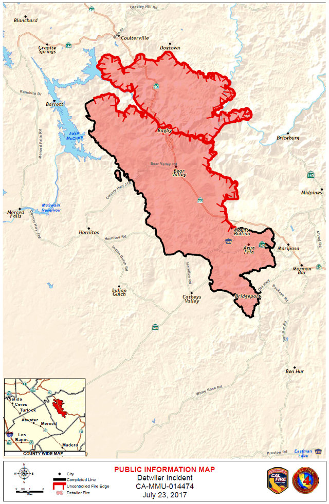
Greeley Hill, CA…The Detwiler fire is now at 78,900 acres and 65% contained While the containment number rising is a good thing almost all of the burned acreage jumps have been on the northern edges of the fire. Even as most of the news from the Detwiler Fire is good there have been some troubling developments on the northern end of the fire. If you look at the map below all of the dark edges of the map are on the southern flank closer to Mariposa. The red or still burning sections of the fire are mostly on the northern end of the fire. What has concerned us from the start of watching this fire is that northern edge. For those of you familiar with that area there is a 500ft to 1,t00 elevation change in a very short distance. The elevation of Coulterville is 1,699 and the elevation of Greeley Hill is 3,153. In general the Rim Fire burned predominately on the eastern side of Hwy 120 on it’s northern flanks. So there is lots of heavy fuel and lots of uphill runs the fire can make in the areas closer to us. They will get this fire but she still unfortunately has more destructive life in her yet. Tragically this area is at least physiologically in the Rim Fire burn scar shadow. For those affected the scars from the Rim Fire are being opened up again South of Groveland.
Click above for the detailed Incident Action Plan which may be of deep interest to those on the norther edge of this fire still in search of fuel.
| Detwiler Fire Incident Information: | ||
| Last Updated: | July 24, 2017 6:45 pm | |
| Date/Time Started: | July 16, 2017 3:56 pm | |
| Administrative Unit: | CAL FIRE Madera-Mariposa-Merced Unit | |
| County: | Mariposa County | |
| Location: | Detwiler Rd and Hunters Valley Rd, 2 miles east of Lake McClure | |
| Acres Burned – Containment: | 78,900 acres – 60% contained | |
| Structures Threatened: | 1,500 | |
| Structures Destroyed: | 63 residences, 67 minor structures and 1 commercial structure destroyed. 13 residences damages and 8 minor structures damaged | |
| Evacuations: | Evacuation Orders All of Schilling Rd * ALL feeder roads Dogtown Rd. from Greeley Hill Rd to Bowers Cave * ALL of Texas Hill Rd * Greeley Hill Rd. from Dogtown Rd. (Coulterville) to Dogtown Rd. near Bowers Cave and all side roads to the South * Bull Creek Rd from Greeley Hill Rd to the Merced River * Old Yosemite Rd to the Five Corners intersectionEvacuation Advisories South County Mariposa. – Mt. Bullion Cuttoff Rd- From Hwy 140 to 72, Princeton Rd- From 49N to 72b,River Road- From Briceburg to North Fork Falls, Hwy 49-S from Ben Hur Rd to Indian Peak Rd and ALL feeder roads, Ashworth to Silver Lane and ALL feeder roads, Silver Bar to Ashworth and ALL feeder roads, Indian Peak to Oak Grove Rd and ALL feeder roads, Oak Grove Rd from Miwuk Rd to Oak Grove School Rd and ALL feeder roads, Detwiler Rd, Hunters Valley Rd, Hunters Valley Access Rd, Cotton Greet Rd, Allred Rd from 49S to Morningstar Lane and ALL feeder roads, Morningstar Lane to Carlton Rd and ALL feeder roads, Carlton Rd to Silva Rd and ALL feeder roads, Silva Rd to Hwy 49 South and ALL feeder roads, Bear Valley Rd- All homes, Hornitos Town Area, HWY 140 from Briceburg to the town area of Mariposa including all roads to the west, Colorado Rd from HWY 140 to Rancheria Creek Rd., Oak Rd and Yosemite Oak Rd and all of Mariposa Town, 49-N from Mariposa to Fremont Fort, Mt Bullion Cuttoff Rd-from 49-N to 72b, School Ln, Rd 72A, Princeton Rd-from 49-N to 72b, Pendola Gardens, Old Toll, Corbett Creek Rd, Mt. Ophir, Hornitos Rd, Mt Gaines, No.9 Rd and Ben Hur Rd from Hwy 49 S. to Buckeye, French Camp Rd, Fournier Rd, Mykleoaks Subdivision, W.Whitlock from 49-N to E. Whitlock and all side roads, HWY 140 from Hornitos Rd to Elizabeth Ln. Old HWY South from 49 S to Totokon, Old HWY South from 49 from Guadalupe Fire Rd to School Lane, HWY 140 from the town of Mariposa to Hornitos Rd and all side roads. E. Whitlock from Hwy 140 to W. Whitlock and all side roads. Colorado Rd and all side roads, Sherlock Rd and all side roads. Evacuation Advisories- HWY 49N from Oakridge Rd. to the County Line. All roads north of Greeley Hill Rd. to the Mariposa County line, to include Dexter Rd., Cueno Rd., Smith Station Rd. to HWY 120 and ALL feeder roads, Buck Meadows Rd. north of Greeley Hill Rd. to HWY 120, Old Yosemite Rd and Bull Creek Rd. The town of Coulterville from Hwy 49N to Lower Dogtown Rd. Evacuation Shelters
|
|
| Road Closures: | HWY49-N- Closed 1 mile North of Bear Valley to Crown Lead Rd, Greeley Hill Rd- Closed from Lower Dog Town to Bowers Cave and all roads to the south, Dog Town Rd- Closed and all side roads, Texas Hill Rd- Closed and all side roads, Schilling Rd- Closed and all side roads. | |
| Cause: | Under Investigation | |
| Cooperating Agencies: | Mariposa County Sheriff’s Office, Mariposa County Fire, CAL OES, CHP, Mariposa Public Works, CALTRANS, Mariposa Public Utility District, BLM, Merced County Fairgrounds, Mariposa County Fairgrounds, California Dept. of Corrections and Rehabilitation, American Red Cross, Mariposa OES ,Mariposa County human Services and Public Health, North Fork Tribal Chair, CDCR CYA Camp, City of San Francisco, TDS Telecom, AT&T, Verizon, Sierra Pacific Industries, PG&E, Tuolumne County Sheriff, Wildland Defense Systems, Sierra Telephone, California State Parks, Salvation Army, United States Forest Service, Federal Team 5, Red Zone Disaster Intelligence, City of Merced, U.S. Senator Feinstein’s Office, California National Guard, John C. Fremont Healthcare District, National Park Service, Sonoma County, Madera Sheriff and Mariposa Health Air Quality, Merced County | |
| Total Fire Personnel: | 5,128 | |
| Total Fire Engines: | 483 | |
| Total Fire Crews: | 116 | |
| Total Helicopters: | 20 | |
| Total Dozers: | 88 | |
| Total Water Tenders: | 65 | |
| Incident Management Team: | CAL FIRE Incident Management Team 4 | |
| Long/Lat: | -120.21321/37.61757 | |
| Conditions: | July 24, 2017 – Detwiler Fire Community Meeting Cancelled.
Last night more containment efforts were made. Further repopulation efforts will continue under the repoplulation plan. Sunny and dry weather continue today. The fire is seeing better humidity recoveries at night. We ask the public to exercise caution and remember that, “One Less Spark-One Less Wildfire”.We ask for the public to heed all evacuation orders and warnings. For information about how to prepare for evacuation please visit: www.ReadyForWildfire.org. |
|
| Phone Numbers | (844) MMU-FIRE (Fire Information Line ) | |
| Phone Numbers | (562) 619-7467 (Media Line ) | |
CAL-FIRE Cancels Greeley Hill Town Hall Because of Fire Activity on North Flank of Detwiler Fire added by admin on
View all posts by admin →