


Arnold, CA…From the National Weather Service in Sacramento the Detailed forecast for West Slope Northern Sierra Nevada. Rest Of Today Mostly sunny. Highs 44 to 59 higher elevations… 56 to 66 lower elevations. Prevailing southwest winds 5 to 15 mph with gusts to around 30 mph. Tonight At lower elevations, rain likely in the evening, then rain and snow likely after midnight. At higher elevations, rain and snow likely. Breezy, colder. Lows 21 to 35 higher elevations…31 to 41 lower elevations. No snow accumulation lower elevations…2 to 4 inches higher elevations. Snow level 7000 feet decreasing to 5500 feet after midnight. Prevailing south winds 10 to 25 mph with gusts to around 45 mph.
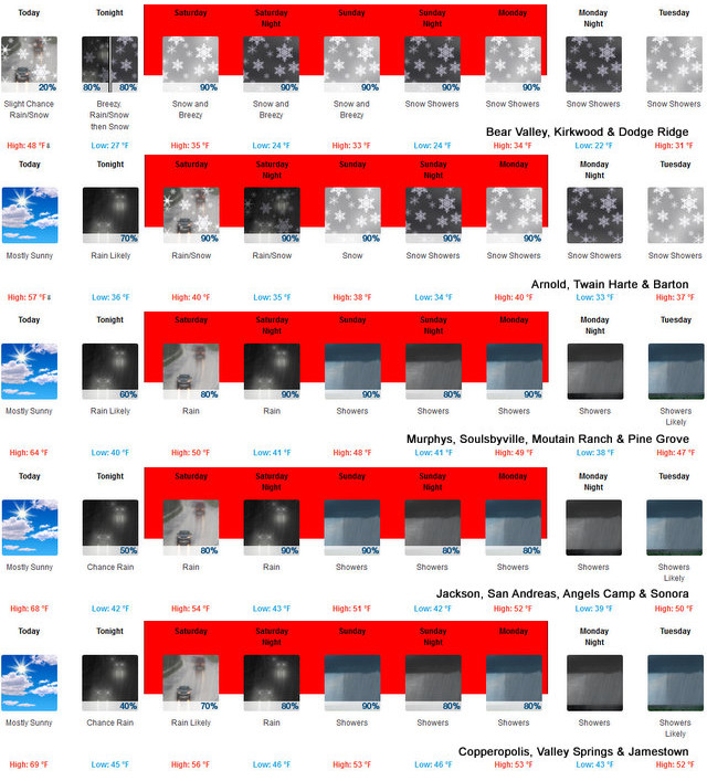
Saturday Rain and snow. Breezy, cooler. Highs 28 to 43 higher elevations…36 to 50 lower elevations. Snow accumulation of 4 to 9 inches. Snow level 4500 feet. Prevailing southwest winds 10 to 25 mph with gusts to around 40 mph…except southwest 25 to 35 mph over ridges.
Saturday Night Snow and heavy rain. Lows 19 to 34 higher elevations…31 to 41 lower elevations. Snow accumulation of 7 to 12 inches. Snow level 4500 feet. Prevailing south winds 10 to 20 mph with gusts to around 40 mph.
Sunday Heavy snow and heavy rain in the morning, then snow showers and heavy rain showers in the afternoon. Breezy. Highs 26 to 41 higher elevations…36 to 48 lower elevations. Snow accumulation of 5 to 10 inches lower elevations…except 13 to 19 inches higher elevations. Snow level 4000 feet. Prevailing southwest winds 10 to 25 mph with gusts to around 45 mph…except southwest 25 to 40 mph over ridges.
Sunday Night Rain and snow showers. Heavy snow accumulations possible. Lows 23 to 38.
Monday Rain and snow showers. Heavy snow accumulations possible. Highs 31 to 46.
Monday Night Rain and snow showers. Moderate snow accumulations possible. Lows 22 to 37.
Tuesday Snow showers. Moderate snow accumulations possible. Highs 29 to 44.
Tuesday Night And Wednesday Mostly cloudy with a chance of snow showers. Lows 18 to 33. Highs 30 to 45.
Wednesday Night And Thursday Mostly cloudy with a chance of rain and snow showers. Lows 19 to 34. Highs 32 to 47.
Winter Storm Warning
URGENT – WINTER WEATHER MESSAGE
National Weather Service Sacramento CA
918 AM PDT Fri Mar 13 2020
…Northern Sierra, Coastal Range, and Southern Cascade Travel
Impacts this Weekend into Monday…
.A cold weather system will bring significant snow to the
Northern Sierra, Coastal Range, and Southern Cascade mountain
ranges this weekend. Snow develops Saturday morning and becomes
moderate to heavy at times Saturday night through Monday.
Generally, snow levels will be 2000 to 4000 feet. Mountain travel
will be very difficult to impossible early Saturday evening and
continuing into early Sunday evening. If you must travel, carry
a winter emergency kit and check road conditions before you go.
CAZ013-014-063-066>069-141400-
/O.UPG.KSTO.WS.A.0002.200314T1800Z-200316T1800Z/
/O.NEW.KSTO.WS.W.0002.200314T1200Z-200317T0000Z/
Shasta Lake Area / Northern Shasta County-
Burney Basin / Eastern Shasta County-
Mountains Southwestern Shasta County to Western Colusa County-
Northeast Foothills/Sacramento Valley-Motherlode-
Western Plumas County/Lassen Park-
West Slope Northern Sierra Nevada-
Including the city of Burney
918 AM PDT Fri Mar 13 2020
…WINTER STORM WARNING IN EFFECT FROM 5 AM SATURDAY TO 5 PM PDT
MONDAY ABOVE 3000 FEET…
* WHAT…Heavy snow expected. Travel will be very difficult to
impossible. Total snow accumulations of 2 to 6 feet above 4000
feet for the Sierra and Southern Cascades, locally higher over
peaks. Total snow accumulations of 8 to 12 inches above 3000
feet for the Coastal Range, locally up to 2 feet over peaks.
Local accumulations of 4 to 8 inches possible down to around
2500 feet.
* WHERE…West slope of the Northern Sierra Nevada, Southern
Cascade Mountain Range, Coastal Range, and portions of the
upper Sierra Foothills.
* WHEN…5 AM Saturday to 5 PM Monday.
* WIND…Wind gusts 40 to 60 mph over the Sierra crest.
* ADDITIONAL DETAILS…Chain controls, major travel delays, and
possible road closures. Whiteout conditions are possible.
PRECAUTIONARY/PREPAREDNESS ACTIONS…
A Winter Storm Warning for snow means there will be snow covered
roads and limited visibilities. Travel is not recommended while
the warning is in effect. If you must travel, keep an extra
flashlight, food and water in your vehicle in case of an
emergency. The latest road conditions for the state you are
calling from can be obtained by calling 5 1 1.
$$
Over Three Feet of Needed Snow Headed To The High Country added by admin on
View all posts by admin →